
Tracking Winter Sailing Under Hazy Skies
Winter days are good sailing days on the Bay, and you don’t even need to own a boat to enjoy them. Here’s proof: Dana Dupar was out last weekend, crewing aboard the Beneteau 393 Irie, so he sent us an email and a couple of photos. And be warned, ‘sailing-envy’ may occur.
“One great thing about winter sailing on the Bay is you get to experience weather patterns different from the nuking westerlies and fog of summer down in the Slot. I was crewing on Irie on Saturday and we covered 26 nm over 4.5 hours of sailing. Although the forecast was for 8 – 10 knots out of the NNW, we had a chilly 12 – 20 knots N, under a hazy sun.”
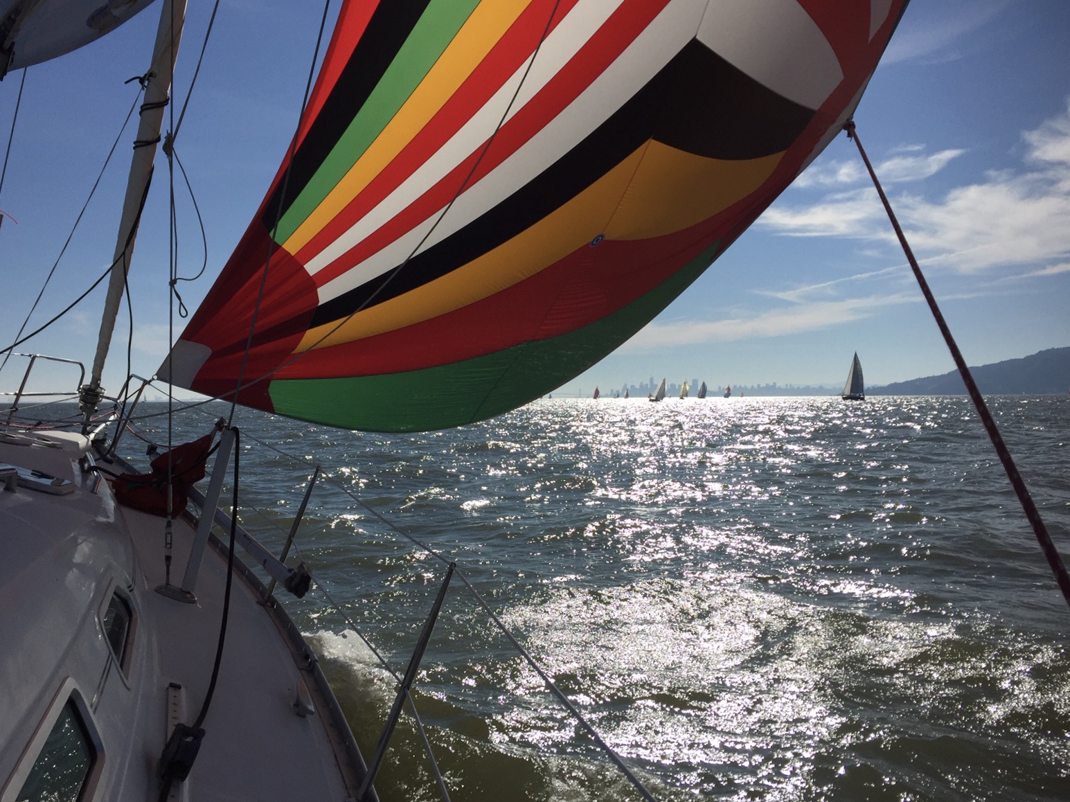
“As usual we chose our route based on wind and tide by first heading for Raccoon Strait, but fog shrouded Richmond, so we jibed and headed for the Gate, which had no fog. What? It was a great experience to sail out past Point Bonita and back under the Bridge with only one tack, which was done to avoid traffic.
“After drifting in the lee of SW Angel Island for lunch (another oddity) we sailed east through Raccoon Strait and back west again without the need for a tack. That doesn’t happen often. One more east-west reach to just enjoy the fresh breeze, and back to Clipper Yacht Harbor, to which we could have sailed all the way on the NW breeze.”
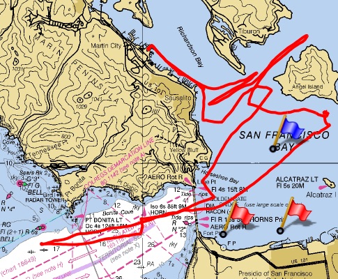
“It would have been a great day for racing, and I fantasized about sailing the Three Bridge Fiasco under such conditions. I’m looking forward to more winter days on the Bay.”
With Christmas only two sleeps away, are you getting ready for a long weekend of sailing? Take your camera, or phone, and send us two or three of your favorite shots from your sail. Remember to include your boat name, type, and where you were sailing and who was aboard. And by all means send us a photo of your track!
Shipwrecked
Fernanda Schlender and I had surfed together quite a bit in the cold, unforgiving San Francisco ocean and were looking for an adventure in warmer water that could test our limits. We never imagined what was to come.
In October 2019, Fernanda had booked us on an epic surf trip at an all-women’s surf resort in Mentawai, West Sumatra. Surfers know this remote island chain because it reportedly has some of the best waves in the world.
We were seven women from all different parts of the world meeting in Padang, West Sumatra — some from Hong Kong, Canada and Australia. After a quick meet-and-greet in the hotel lobby, we were escorted to our boat for the 14-hour journey to the islands.
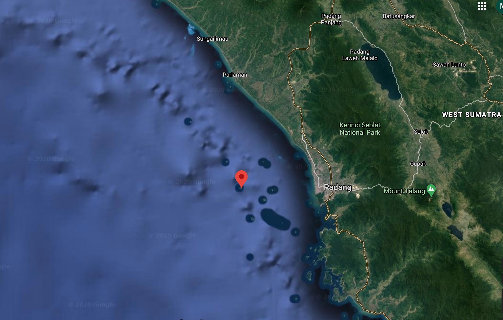
As we boarded the 60-ft wooden boat, I remember thinking, “This boat does NOT appear safe.” I’ve heard many stories about the unforgiving passage in West Sumatra — stories about boats sinking and its being one of the most dangerous places for piracy. However, I never thought we would end up as one more story.
We settled in for the trip, and at about 9 p.m. we headed down to our bunks underneath the galley. We were about three hours offshore and sound asleep when there was a loud crash and the boat started dragging and shaking.
Fernanda and I were the first to jump out of bed and run to the exit. The sliding door was jammed and wouldn’t open. There were no windows in the bunk area to see what was happening outside, and at this point, the boat was already on a 45-degree angle to its starboard side, and crashing waves were coming in through the port side.
Fernanda grabbed an object to break the door open, but despite our pounding and kicking, the door wouldn’t budge. We were trapped, with waves crashing in. At that moment, I thought, “This is it. We are trapped and sinking. This is how it will end.” Fortunately, an Indonesian crewmember, who was trapped in the bunk area with us, ran to our aid. Together, with all our forces, we were finally able to slide the door open and get on deck.
We arrived on deck to complete chaos — crashing waves and an unstable boat. I saw we had hit the shallows and were aground and listing badly. As I scanned the area, I happened to see a small island in the distance.
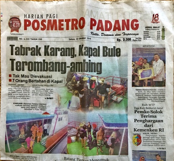
There were about 20 young Indonesian crewmembers — none spoke English, none knew how to swim, and all were in a state of panic, running back and forth. Fernanda and I ran to the bow of the boat to grab the lifejackets and began handing them out.
At this point, the boat was continuously being hit with crashing waves, causing it to shake violently as the heavy cargo on board slid from side to side and bow to stern. The captain, an old Indonesian man, came out and yelled in broken English, “Sit on the starboard side of the stern — SIT!” This seemed to be a strange order from the captain as the starboard side was on the verge of being submerged in water.
Please continue reading at Latitude38.com.
The Canvas Works

Good quality boat cushions are important for both form and function. Let us help you freshen up your boat deck, salon or sleeping area.
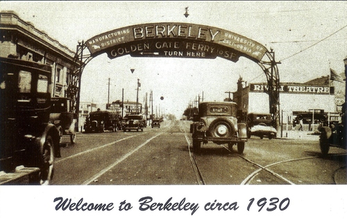
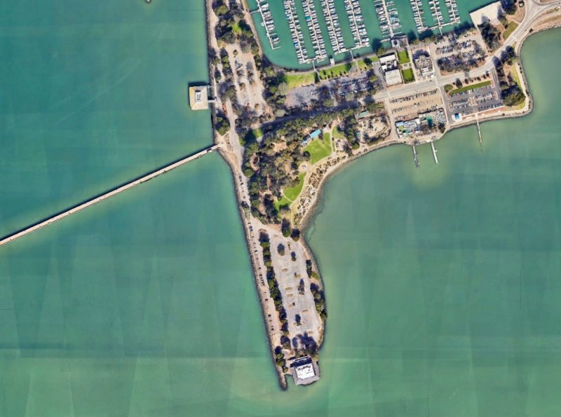
The New Ferry-Line Proposal for Berkeley Marina, Part 2
In 1927, the Golden Gate Ferry Company built a three-and-a-half-mile-long pier at the base of University Avenue, in Berkeley. The small university town had absorbed thousands of refugees after the1906 Great San Francisco Earthquake. By 1936 — just over a year before the Bay Bridge and Golden Gate opened — some 50,000 people ferried across the Bay daily, according to KQED. “There was a rebirth of ferries in the 1970s, during the oil crisis, and again in the early 1990s after the 1989 Loma Prieta earthquake. But after that, ferries sort of stumbled along.”
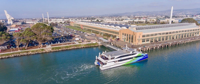
In 2009, a new ferry in Berkeley seemed all but inevitable. “Berkeley is moving full-steam ahead with plans for a new ferry terminal, despite howls from windsurfers and environmentalists that the ferries will bring the marina more harm than good,” SF Gate wrote in December 2009. Berkeley’s city council had approved plans for a waterfront terminal south of the then-open Berkeley Pier. Two ferries running during commuting hours were expected to bring 1,700 people a day to San Francisco. A former councilmember said that the ferry system would be one of the spines of the transportation system, adding, “When, not if, the Hayward Fault lets loose, this will be an ideal way to get people around the Bay.”
But the project was “all but abandoned in 2013 over concerns about dredging, funding and conflicts with other uses for the Marina,” Bay Crossings reported. While Berkeley’s situation is unique, the discussion of the pros and cons of a ferry line will continue around the Bay as ferry service grows in (pre-pandemic) popularity and public investment, and the Bay’s largest public-ferry commuter line — the Water Emergency Transportation Authority, or WETA — has a vision that “ferries run every 15 minutes in the highest-volume locations, and that commuting by ferry is the first-choice travel option for thousands more Bay Area residents every day.”
As we reported on Monday, the Berkeley ferry project has been revived, due in no small part to the city’s need to “reopen the pier for public recreation in the most cost-effective manner,” according to Scott Ferris, the Director of Parks, Recreation and Waterfront. (The new pier is described as “dual-ferry-and-recreation use;” the former pier was super-popular with fishermen and walkers.) The ferry will soon be discussed in a yearlong public-engagement process. “The City’s Local Hazard Mitigation Plan has identified developing a partnership with ferry service as a high-priority action that would play an important role in the city’s emergency response and recovery after a major disaster,” Ferris added.
In 2019, when the WETA board of directors voted four to one to pursue the Berkeley ferry, the dissenting vote argued that the proposed Marina terminal was not in accord with WETA’s objective of building near residential and commercial centers, according to Bay Crossings. “The problem with this site is it is virtually impossible to develop housing or commercial space within walking distance,” now-former board member Nick Josefowitz argued.
So, how many people plan to ride a Berkeley/San Francisco boat? What commuter needs on both ends of the Berkeley line will be fulfilled? Given that one of WETA’s goals is to relieve congestion on Bay Area highways, how many vehicles are expected to be removed from the daily commute?
Ferris cited the WETA ridership statistics. “The 2035 projected daily ridership for the Berkeley service is 1,589 (795 unique individuals). Annual ridership on the Berkeley ferry is projected to be just over 203,000 in the first year and increase by 1.78% annually.” Some sources have told us they believe that ferry-ridership demands have been traditionally overestimated, since Berkeley has two stops along the BART line and is close to the Bay Bridge, and because the Marina is well removed from the rest of the city.
In 2009, a public comment submitted to the WETA board of directors read, “It is critical that accurate and consistent figures are used for both economic and environmental impact planning, and that decision-makers and all communities be fully informed of the financial consequences if actual ridership does not meet projections.” Even though WETA now has access to more cash via a recent bond measure, transparency will be key in creating compromises.
Location, Location, Location. And Dredging.
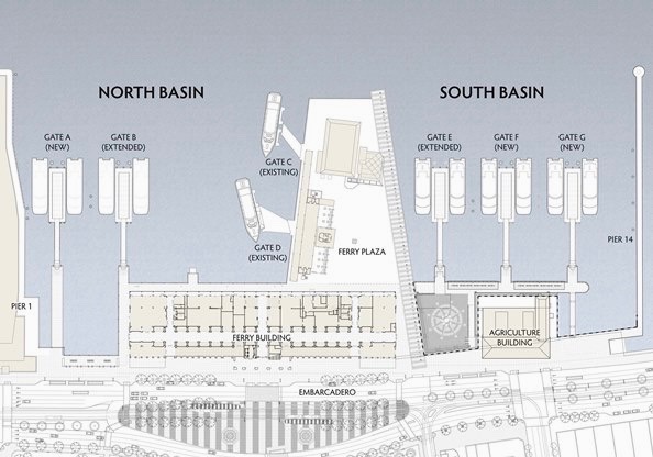
Recent designs in a recent City of Berkeley report show two options for a terminal on the south side of the University Avenue pier, a small swath of water currently used by windsurfers, kayakers and swimmers. We have heard suggestions for putting the terminal on the north side of the pier to avoid cutting into those waters — an option that will surely be floated during the engagement process.
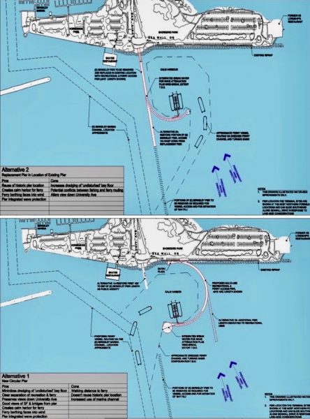
As mentioned, one of the concerns with the 2009 proposal was additional dredging of a second channel angling from the main marina thoroughfare. Is there a potential combined benefit to having ferries use and actively dredge the existing channel, with the Marina entrance “thrown in” as part of the deal? A recent comment from a former Berkeley Marina slipholder told us, “With just a 6-ft draft, we would run aground in the [Marina] entrance at low water.”
“Dredging options will be a part of the public process,” Ferris told us.
(Could the new ferry terminal be built inside the Marina? “The City and WETA are specifically looking at the feasibility of building the ferry terminal as part of a joint project to reconstruct the Berkeley Municipal Pier,” Ferris said. “Neither the City nor WETA are currently considering the construction of a new ferry terminal inside the Berkeley Marina.”)
Where Do You Put all Those Cars?
During the 2009 Berkeley ferry proposal, a source told us that WETA wanted 400 dedicated parking spaces at the Marina — a substantial chunk of real estate. Skeptics of the ferry say that because the Marina is almost entirely funded by berthers and marina businesses, parking should be prioritized for those uses, and should not have to compete with a ferry.
Scott Ferris told us that parking reduction strategies will be considered to reduce the number of cars used by ferry commuters. “Additional parking spaces may need to be created in the Marina to accommodate the parking needs from the ferry services,” he said.
“There are ways to run a ferry service without massive amounts of parking, but so far these suggestions have not had any traction,” wrote Paul Kamen, who serves on the Berkeley Parks and Waterfront Commission. “For example, coordinate the ferry schedule with a shuttle bus from campus up and down University Ave, and set up the terminal so the only way to get on the ferry is by getting off the bus. All walk-ins at the ferry terminal could then be assumed to have parked in the marina for the day and would be charged an appropriately steep parking fee.”
Where do you put all those cars currently on the road if there aren’t more transportation options in the future? The Bay Area’s Regional Transportation Plan predicts a 21% increase in the number of personal vehicles per household, or an addition of 1.1 million cars over the next 20 years. That’s 55,000 cars a year. Can any of us imagine traffic getting worse than it already is?
At some point, cities, counties, states and nations will need to have an honest conversation about the sustainability of their populations. In 2017, transportation represented 60% of California’s carbon dioxide emissions. Whatever transportation solutions cities come up with, they need to be leaner and greener, and compete with finite space on the roads.
Let’s Forget About Ferries for a Flash …
After we wrote about the improvements in the South Basin a few weeks ago, two former slipholders wrote us about the condition of the docks. Berther or slip fees used to make up half of the Marina’s budget; that number has fallen as boats have left.
This spring, the Marina will see the initial phases of a $20 million investment of safety and infrastructure improvements, “including work on the docks, pilings, restrooms and streets,” Ferris said.
Four berther restroom buildings were remodeled in the last year. Finger docks and pilings will soon be replaced. The Marina’s electrical system will also be upgraded on docks J, K, L and M. The city also has nearly $6 million loan from the Department of Boating and Watererways to fully replace D- and E-docks, “which are in the worst shape,” the official said.
“The goal is to make our waterfront safe, secure and structurally sound,” Ferris told us. “We allocated millions in infrastructure improvements to our waterfront over the last three years, and we’ve made good progress. I am confident that our upcoming investments will get us over the hump, and that the long-range planning efforts kicking off this January will help propel the waterfront and the Marina Fund to a brighter future.”
Any discussion of Berkeley Marina has to include the homeless problem and related security issues. For several years now, there’s been a large encampment — which sits on state land and is under its jurisdiction — on a freeway buffer at the intersection of West Frontage Road and University Avenue. Catrans occasionally razes the area, but the outed occupants return immediately. As always, homelessness is outside the scope of this magazine, but the homeless issue will have to be confronted before Berkeley Marina can truly realize its glory.
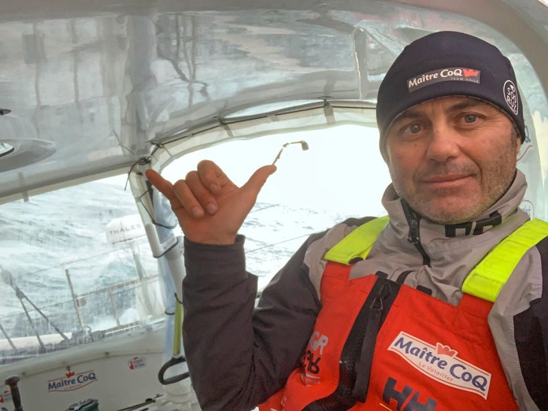
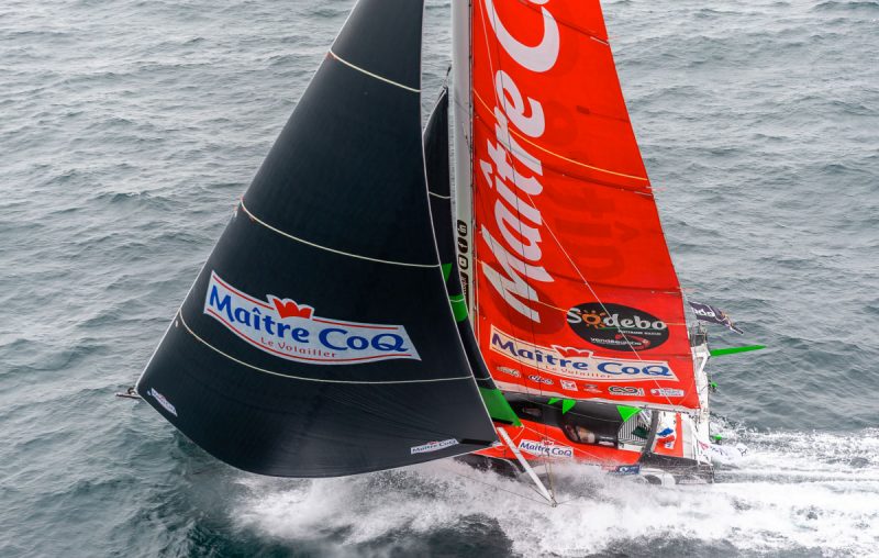
Strangely Tight Vendée Globe Races through the Southern Ocean
More than 45 days into the ninth edition of the Vendée Globe, Yannick Bestaven on Maître CoQ IV continues to lead the race and now threatens to break away. Pre-race favorites Apivia and LinkedOut can only hold on and wait with bated breath to see if they can stay in touch with this previously improbable leader.
“I have a little more wind than forecast, and I am happy,” said LinkedOut’s Thomas Ruyant in his latest interview with Vendée Globe Live. “But the big question is: ‘Is the high pressure going to be fast enough to catch Yannick?’” Ruyant is currently in second place with rival Charlie Dalin and Apivia off to his south in third place; both skippers are entering a zone of high pressure and light winds. Just ahead of them, Yannick Bestaven on Maître CoQ IV is pushing hard to stay ahead of the high pressure and in the southerly airflow that could propel him to a decisive breakaway. The lead trio are now about halfway between New Zealand and Point Nemo, the most remote location on Earth.
Behind the top three foilers, the second pack of pursuers, from fourth-place Boris Hermann to ninth-place Giancarlo Pedote, continue to stay in contention. Pedote and Prysmian Group remain just 400 miles behind the leader after 45 days of racing. At no point in Vendée Globe history has the race ever remained this close this long.
Making the race slightly more confusing but ironically even closer, an international jury has awarded redress to three of the top skippers who participated in the daring search for and rescue of PRB’s Kevin Escoffier after his boat sank south of the Cape of Good Hope. Jean Le Cam rescued Escoffier and dropped him off to the French navy a week later. Le Cam was deemed to have gone 16 hours and 15 minutes out of his way for the rescue. He’ll be awarded that amount of time, to be taken off his final finish at the end of the race. Yannick Bestaven will receive 10 hours redress, and Boris Hermann was awarded 6 hours. These times will all be deducted from the final finish times. With racing this tight, these time adjustments could likely be the difference in one or more positions, and could help reshape the podium.
The record-breaking 27 boats still in this race span about one ocean in distance, from mid-Indian Ocean to mid-Pacific. Now very far off the event’s record pace, this Vendée Globe will almost certainly be slower than the last edition and perhaps even slower than the 2012 race, despite the fact that the boats have gotten so much faster over the last one and two generations, respectively.
With a slow descent of the Atlantic and a relatively benign and slow crossing of the southern Indian Ocean and the Pacific, the attrition rate has been lower than normal. In a typical Vendée Globe, only about half of the fleet usually reaches the finish line. In this race more than 80% of the fleet is poised to reach the halfway mark, which would be a race record. Race leader Yannick Bestaven is close to 3,000 miles from Cape Horn. Look for an update in about a week, when the leaders take on the final one of the three Great Capes.
Merry Christmas to all our Readers
It’s that time of year again: Christmas is upon us, and while many will be celebrating and sharing festivities with family and friends, there are many who are unfortunately facing a less than merry holiday season. We don’t want to be a ‘downer’, but please take care and extra time to acknowledge and check in with your neighbors this year. You never really know how much difference one moment of kindness, or even a heartfelt smile, can make to another person.
That said, we wish you all the best of fun and happiness for the days ahead, and we hope you get to go sailing!
As Friday is Christmas Day, we won’t be posting a new issue of ‘Lectronic Latitude, but we will be back on Monday, ready to share stories and photos of your weekend sailing adventures.
Please send us photos and tell us where and aboard what you were sailing, and who were your crew. Email us at [email protected]. And you get extra points for including sailing-Santa photos or decorated boats.
Merry Christmas, sailors!