
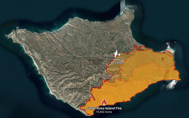
Santa Rosa Island Fire Continues To Burn
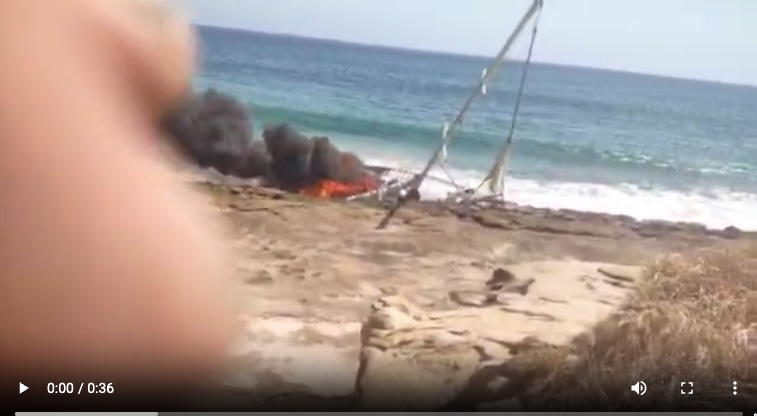
The bad news continues from Santa Rosa Island. The fire has now burned almost 17,000 acres on the 50,000-acre island and is only 26% contained. News reports now have more detail on the boat, which was on fire as it lay on its side, wrecked on the beach. It’s reported to be a 54-ft sailboat named Wet Vette that sails out of Long Beach.
The owner recorded a video of the boat on fire, saying in the video, “Wow, that is a hot fire, I hope it doesn’t start this island on fire; that wouldn’t be good.” As reported on Monday, the sailor, who unsurprisingly wishes to remain anonymous, inexplicably felt compelled to fire off flares to alert local fishermen about his need for rescue. A tragic mistake.
As many commenters pointed out in the comments on Monday, there are many potentially better ways to signal distress besides firing off flares near dry grassland. Locals report there is no cell service there so a cell phone wouldn’t work unless you have a model with the ability to send SOS signals. A working handheld VHF would likely be best since it would reach any nearby boat monitoring Channel 16 (which we should all be doing while boating). An EPIRB would also summon help, and non-pyrotechnic flares like Sirius Signal could also work.
Regardless of the rescue options, Santa Rosa is an inhabited island with roads, paths and people nearby. The sailor was reported to be uninjured, so we continue to be mystified regarding what the urgency was for rescue, unless it was perhaps a misplaced hope that the boat could be saved.
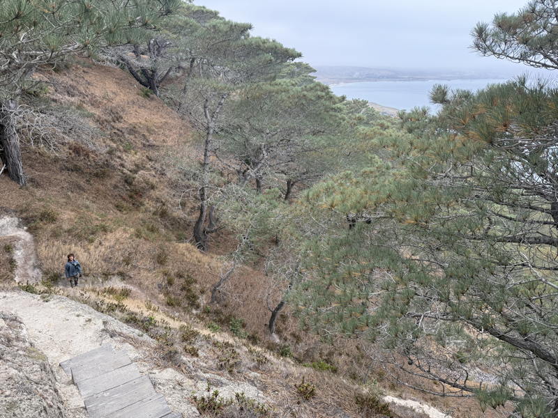
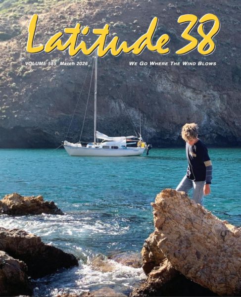
Don Litton, whose Columbia 29 Pythagoras appeared on our March cover and who has regularly cruised these islands with his family, wrote in our Monday comments of the incredible sadness he’s feeling for the islands and the endangered Torrey pines, which grow only on Santa Rosa Island and in the San Diego area.
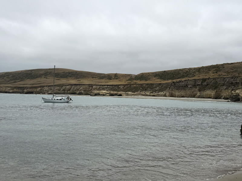
Don describes the area behind the photo: “The coast beyond the boat in the anchorage has burned, according to the CAL FIRE map. The area has a great deal of Chumash artifacts. It appears to have been a feasting and gathering spot.”
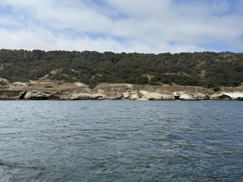
Don describes Becher’s Bay as the main anchorage there, with the best area up at the pier in the northwest corner of the bay. “I took the shots as I was sailing northwest toward the pier, if that makes sense. It’s not an anchorage there though one could; it’s all sandy bottom there and sheltered from the prevailing NW swell. In the afternoon that wouldn’t be comfortable as it gets really windy and choppy there.”
The Channel Islands are one of California’s great treasures, and we were happy to learn more when Don Litton wrote about his family cruising on Pythagoras. Though most photos we see of cruising these remote islands show empty anchorages, we know it’s a cherished destination for many Southern California sailors or those who cruise south from Alaska on down.
The video taken by the Wet Vette sailor can be seen in this television news report. We hope to learn more over time and hope the fire can be brought under control quickly. It’s a popular destination for Memorial Day Weekend.
I wonder why the boat caught on fire. I know it was hung up on the rocks but surprised at the fire since it was a sailboat. It appears that fuel tank was apparently punctured and then something sparked to start the fire. I’d love to know what the owner says happened
Thanks John.
In the report I thought this part did not bode well for the sailor:
“On Tuesday, Channel Watch stated that the 67-year-old shared with them that the sailboat he was piloting had run aground in the afternoon of May 14, a day earlier than previously reported, due to heavy surf. Around 3 p.m., the vessel caught fire, but the smoke did not attract the attention of passing ships as the man had hoped.”
It’s getting more difficult to be charitable with this gentleman.
First of all I would like to be clear that I am not defending the actions of the skipper may be responsible for the fire, but, it is unfair to cast negative judgement on him with completely false information. With all due respect Mr. Arndt, this statement is untrue: “Regardless of the rescue options, Santa Rosa is an inhabited island with roads, paths and people nearby.” The only inhabitants are National park employees, researchers and volunteers that come and go as there job requires. Island Packers (where I was a Captain) delivers visitors to the pier at Bechers bay for both day and overnight camping at a nearby campground. The ranger station, at Bechers, is 14 miles on a dry dirt road with little to no shade and an elevation of 1500′ from the very desolate location where the boat went aground. Very few people travel or hike there because it is a 28 mile round trip. Camping outside the campground requires an application for a seasonal use. You will rarely see people on the island and few boats in the area of the grounding. Wind and rough seas are a major deterrent. This statement is also very misleading and indicates that don has very little knowledge on the topic: ” It’s not an anchorage there though one could; it’s all sandy bottom there and sheltered from the prevailing NW swell. In the afternoon that wouldn’t be comfortable as it gets really windy and choppy there.” Here is what AI has to say: Yes, Bechers Bay (often referred to as Bechers) is the main port of entry and a prominent anchorage on Santa Rosa Island. The Northwest Anchorage in Bechers Bay is highly popular and well-protected from ocean swells” Yeah it gets very windy and you have to know where to anchor. I have spent many nights there and is one of the best calmest anchorages in the Channel Islands even with the very typical prevailing 30 tp 40 knot afternoon/evening winds. Even when the surf is pumping at 6′-8′. So it would definitely appear that this guy made a myriad of bad decisions. But lets get the facts and avoid spreading misinformation before a proper investigation is done. I was also a docent on the island and had the great privilege to be flown out to the island, Scared the p out of me landing on that runway with those gale force winds. I will stick to boats, thank you very much! The fire is a terrible tragedy and sickens my heart as well.
I believe he went aground near wreck canyon. The view that I shot of the pines was within Bechers Bay. I’ve seen boats anchor there (between Southeast anchorage and the pier or Northwest anchorage) for the day only. I have not had any reason to anchor along there. I’ve anchored many times near the pier and I agree it is one of the calmest anchorages in terms of swells and it is one of the windiest. I think you may have misunderstood what I was referring to. At any rate you are correct in what you say about the hike from the ranger station to the south side. Neither John nor I want to mislead anyone.
Reading the article and your response again, I see (finally) that you thought I said there are people close by or living close by to where the sailor went aground. No, I would definitely agree with you that few people make the hike out there. He had a better chance of being seen from the beach than trying to make the trek to the ranch. Without food or water, or good shoes, and without knowing where the road was, he was actually better off at the beach in that part of the island at that particular time IMO.
I hope I don’t jinx anything but the current map is encouraging. It is not showing any new heat signatures from the satellite view. It looks like they may have a good line on it now. Thank God for those guys and gals out there putting that thing out!
The preferred anchorage is 1.3 knm due north of the pier in shallow water with sand bottom tucked behind the cliffs. Not near the pier. Of course you have to make adjustments for any ground swell making it in there, rare.
Still very windy, but , quite calm. Like being in the slip, that is if, if you provision your sail boat so it does not tack at anchor. I have seen waves actually breaking over the top of the pier. Just have to anchor in deeper water. Southeast Anchorage is 1.1 knm SE of the pier (N side of Skunk point) and offers excellent protection (& surfing) during SE winter storms. As far as the boat grounding, can’t help but consider it was deliberate. Very isolated location with very few, if any witnesses.
From a cruising standpoint I’d like to clear up where I think Captain Kirk misunderstood me. While the Northwest anchorage is well protected by swell, Southeast anchorage in Bechers gets choppy in the afternoon and swells that bend around Carrington point join in the mix making it uncomfortable. I have stayed in Southeast only once at night, preferring instead to move up to the pier in the afternoon. Southeast is also very shallow (10 to 11’) if you want to try to tuck in behind its little rocky point. But the good thing about Southeast is that you are right there at the pine grove and a short walk out to Skunk point. So it’s a great place up until about 1:00 or 2:00 typically in my experience. If you skippered for Island Packers then I happily concede you have far more experience there!
Hey Don, you are absolutely right about SE anchorage and the entirety of Bechers bay. There are some of the most fantastic beaches there when weather permits. SE anchorage is a dangerous lee shore most every afternoon with prevailing conditions. NO where to spend the night other than during SE wind evnts as the name somewhat implies. We anchored just off the water canyon when my kids were toddlers with the intention camping there. They had so much fun playing on the sand dunes. We pretended we were riding on the backs of a dinosaur. Unfortunately the campground had not been well developed or maintained and resembled a cattle corral. The park ranger was also very rude and wanted to know why we were there and then made us feel very unwelcome. This was around 1994. We packed it up and went and spent a fabulous weekend at Coches instead. Was a bit of an adjustment since we had planned on being on the land instead of the boat.
Just one other thing to be aware of. No one is allowed beyond the high tideline at Skunk point. It is a refuge for the Snowy Plovers.
Some good news today about the Torrey pines!
https://inciweb.wildfire.gov/incident-publication/cacnp-santa-rosa-island-fire/videos-of-the-torrey-pines-during-the-2026-santa-rosa-island-fire-channel-islands-national-park-released-on-05-21-2026