
Want To Have a Say in What a Pedestrian Bridge Over the Oakland Estuary Might Look Like?
In late November 2022, the City of Alameda held the first of what will be many, many public meetings about a proposed pedestrian bridge spanning the Oakland Estuary, from Jack London Square to the northeastern shore of Alameda.
The City is asking for sailors’ input.
Plans for the bridge have been under study since 2009, though many of us hadn’t heard about the project until a few months ago. The reception was less than enthusiastic. There is still discussion of a water taxi that would service the Estuary, but regardless, plans for the bridge seem to be moving full-steam-ahead. (A water taxi would obviously be limited in hours; the bridge would be open 24/7.)
How tall will the bridge be? How will it affect sailing on the Estuary? How often does the City expect the drawbridge section to be opened on a typical high-water-traffic day (aka the weekend)?
At the November Zoom meeting, we asked these very questions.
The height of the bridge has not yet been determined, but there will certainly be a drawbridge section to accommodate Coast Guard cutters stationed in Alameda. “We’re working closely with the Coast Guard,” an Alameda city planner said at the meeting.
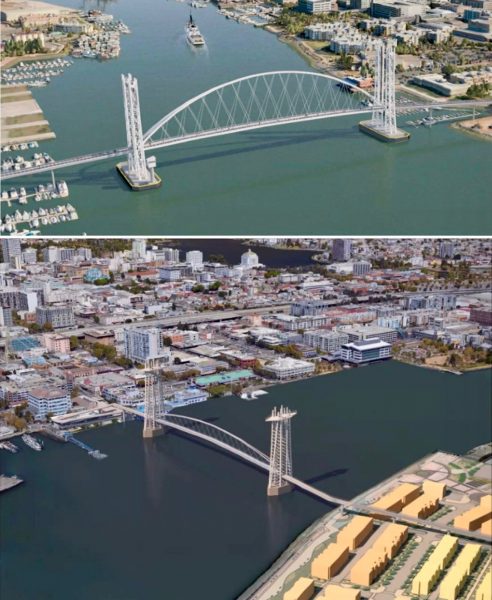
We’ve been wondering what the ideal height would be so that the largest possible majority of boats can pass through on most tides. Would that be about 70-ft? What’s the ideal height for the average size of boats racing on Friday nights?
“There’s going to be a ton of tradeoffs,” a City of Alameda employee said, admitting that a lower height was more desirable for bikers to avoid steep inclines at either end of the bridge, and that a larger height was more desirable for sailors.
“We have to figure this thing out together,” the city employee said, adding that “data” were needed.
We cannot stress enough the need for organized advocacy, nor can Latitude carry that particular torch entirely on our own. We hope that someone, or an organized group, can assume the role of “quarterback” and start to marshal data and stakeholders, and lobby on behalf of sailors.
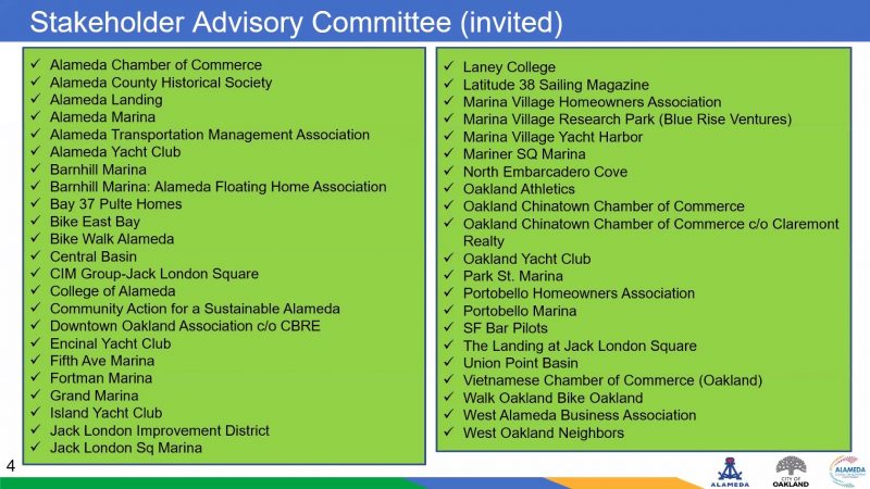
We were one of maybe three advocates for boating at the November Zoom meeting, though a number of marinas and yacht clubs had apparently been invited. There were, however, a large handful — maybe between five and a dozen — of bike-advocacy groups in attendance.
Clearly, there is work to be done.
“Please note that we will be doing much more extensive public outreach in early 2023, and will have more materials for the public to review,” Rochelle Wheeler, the senior transportation coordinator for the City of Alameda, told us in an email. “The city will continue to engage with maritime industry and all interested folks throughout the project development, so now is certainly not the only opportunity for commenting,” she added.
Here’s the official page for the proposed bridge, where you can sign up for updates: www.alamedaca.gov/bridge.
Here’s a link to Rochelle Wheeler’s email if you’d like to make specific comments. You can also reach out to Frank Ponciano, a consultant who’s also taking input on the bridge.
How about a double decked bike and pedestrian walkway air-conditioned tube inside the Posey tube where the existing walkway is. With pretty murals inside and security cameras.
Just trying to think outside the box a bit for a way to save a huge expense for a project that probably won’t make anyone happy.
Reading the Estuary Crossing Study, I can’t help but think that a bridge is a foregone conclusion and they’re working backwards from there. Independent of whether a bridge is a good idea or not, the language used to weigh the pros/cons of the alternatives seems quite biased.
Case in point:
“The Fruitvale Bridge is located approximately three miles southeast of the Posey Tube, and currently provides a physically separated, bi-directional path on each side of the vehicular bridge, which is also shared by pedestrians. This facility does not provide a convenient travel option for pedestrians and cyclists seeking to travel between west Alameda and downtown Oakland. Park Street and High Street provide alternate crossings for pedestrians and bicyclists near the Fruitvale Bridge. Nevertheless, neither are designated bikeways. As a comparison, a bicyclist riding between the College of Alameda and Lake Merritt BART station would travel almost two miles using the Posey Tube and six miles using the Fruitvale Bridge corridor.”
“This facility does not provide a convenient travel option for pedestrians and cyclists”…does not or could not? Shouldn’t the point of a study like this be to understand whether it *could*?
If you’re trying to get to from West Alameda to Jack London Square most routing directions will take you across Park St Bridge. The problem is not the 2mi ride from West Alameda to the bridge or that it’s not a dedicated bike path, the problem is that as soon as you’re on the Oakland side you’re on unsafe, industrial, poorly lit, heavily polluted roads, often with shoulders loaded up with burnt out cars, RVs, chop shops, human waste etc.
Short circuiting West Alameda and Jack London Square with a bridge might seem like a great idea (it’s only a 1mi ride if that’s exactly your starting point and destination!), but the reality is that it’s a great bike network not a singular bike path that increases bike traffic.
Alameda seems to be proof that people will use well developed bike networks to travel longer distances. e.g. from my house in Alameda, it’s 20 minutes bike ride to Almanac Brewing OR 20 minutes bike ride to Jack London Square. I *never* ride to Jack London Square, but I happily ride my bike to Almanac, and I’d happily take someone that’s not an avid cyclist. If I want to go to JLS I ride my bike to the ferry terminal then take the ferry over.
It also seems like the elephant in the room is that increased development is going to mean increased car traffic, so there’s probably going to need to be development to accommodate increase in car traffic on/off the island. It might sound crazy to spend 7 million to modify the Posey Tube or 200 million to build a new tube just for pedestrians/bikes (per this study), but if the tube is already being overhauled for vehicle traffic then perhaps pedestrians and bikes can be considered at the same time, with a design that avoids current issues (noise, pollution, space, security).
Agree with Steve above about upgrading Posey Tube instead. It’s barely wide enough for a bike, extremely intimidating to navigate with auto traffic, bikes can only use one side for going in either direction, and ear plugs are needed because it’s so loud in there. Otherwise, a pedestrian bridge needs to be at least 60 feet high to accommodate my Freedom 38.
I agree with Nathan about the language used, especially as it relates to the use of the Fruitvale Bridge as a bike route. I have used that route for many years to get to from Oakland to Alameda and the most dangerous part of my trip by far is on the Oakland side of the bridge.
It’s not the time travelled, but the physical obstacles (broken pavement, being forced to ride against traffic, debris in the path) that make that ride undesirable. I suspect it would be far less expensive to improve that existing bike path than to build an entirely new bridge that would only marginally improve bike travel time, but could significantly disrupt boat use of the Estuary.
What does the bridge do to ships using the turnaround if anything?
It looks like the Estuary boating world could go the way of the
San Leandro marina.
How high does the bridge need to be? Why not a fixed bridge with multiple elevators on each end?
I was thinking the same thing. I bet two elevators is a lot less expensive than a movable bridge, and avoids the need for it to be staffed 7/24.