
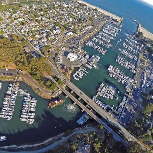
Is Santa Cruz Harbor Poorly Designed? Yes, It Is
After gut-wrenching video of waves peeling through Santa Cruz Small Craft Harbor during Christmas week showed boats thrashing and snapping their cleats, causing some $25 million in damage to harbor infrastructure and sinking 12 boats (including at least one liveaboard), a few readers shared their experiences of being docked inside the 1,000-plus-slip marina.
“We were there for the Tsunamis. Isn’t [it] about time a more protected entrance was installed? When the entrance is a direct shot, why wouldn’t you expect this?” asked one reader. “Santa Cruz Harbor is not a harbor to keep an expensive boat in the winter,” said another reader.
One reader said that the harbor’s issues were baked into its DNA, and might have been avoided. “This harbor was placed incorrectly in 1964 against advice of long-time mariners. The Army Corps of Engineers ignored advice.”
The March 2011 Tōhoku earthquake and tsunami put Santa Cruz Harbor’s flaws in the spotlight.
“More than a week after a tsunami forced its way into the Santa Cruz harbor like a rushing river, questions have surfaced about whether the port design and topography of its basin may have contributed to the surge’s estimated $26 million in damage,” the Santa Cruz Sentinel wrote in 2011. “At the Moss Landing Harbor District, just 24 miles to the south, the tsunami’s impact was far less severe. With a deeper harbor mouth and a channel that empties into several sloughs, Moss Landing experienced no loss to boats or docks.” Fourteen boats sank and a number of docks sustained major damage in Santa Cruz Harbor following the events of 2011.
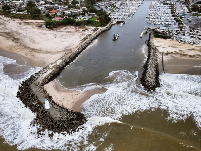
But the tsunami revealed only part of the harbor’s flaws. “Designed by the Army Corps of Engineers, the channel narrows and veers off on an angle as it spills into the confined upper harbor, where the tsunami became magnified,” the Sentinel wrote. “‘We had people ask the question of whether a different configuration of the jetty or seawall parallel to the sea would have affected some of the wave energy,’ said Port Commission member Jeff Martin, who is also a civil engineer. ‘Could they have designed it better? I think so.'”
Martin, who is no longer a commissioner, said there was a “low degree of likelihood” that the Port District would pursue any major redesign — and that was nearly 14 years ago.
So the answer is emphatically yes, Santa Cruz Harbor has some design flaws that have left it exposed it to the elements. It doesn’t appear as though a major infrastructure investment is coming any time soon, given the massive price tag associated with the Christmas-week surge and the collapse of the wharf. “The California Governor’s Office of Emergency Services is expected to decide in the coming weeks whether to ratify an emergency proclamation to unlock state money for repairs on the Santa Cruz Municipal Wharf and parts of the Santa Cruz Small Craft Harbor damaged by large surf on December 23,” Santa Cruz Local reported. Now that we’ve stated the obvious and answered our own question, we’re curious to hear about your experiences in Santa Cruz. The Small Craft Harbor’s unique (and less-than-ideal) design has us thinking about other sporty — one might say sketchy — harbors throughout the world. Please comment below, or write us here.
This story might read like a hit piece trying to dissuade sailors from visiting the gem that is Santa Cruz and Monterey Bay. That is not the case! While the harbor could clearly benefit from another breakwater, Santa Cruz is an incredible destination worthy of sailors’ attention, and deserving of our dollars in its efforts to rebuild.
I think it’s important to differentiate the break at the entrance to the harbor, where ocean swells break every 10 seconds or so, with the very long period waves associated with tsunamis and the recent storm. Initially when the Fukushima waves reached the harbor, it was about 20 minute between surges. I think what we saw in the recent storm was a wave period of perhaps 90 seconds, which welled up as it traveled up the narrower and shallower upper (North) harbor, with no way to dissipate the energy.
To make matters chronically worse, the harbor is a delta to Arana Creek and the Arana watershed is quite prone to significant erosion.
We have a 54′ sailboat and have visited Santa Cruz harbor many times. There is always surge in the harbor, even when the sea outside the harbor appears to be flat. Our worst experience was in June, 2023. We were bringing our boat up the coast after wintering in Mexico, and we decided to stop in Santa Cruz for a couple of nights. We arrived about 0400, and followed the harbor masters instructions to tie up to the fuel dock until they got into the office and could find us an end tie. Though there was only 1′ – 2′ seas outside, they were from the south, and when we tied to the fuel dock (which is close to the harbor entrance) we were bouncing 2′ – 3′ alongside the dock. I put out our storm lines and gave them the longest lead I could (including tying across the dock) and we didn’t part any lines but it was miserable wait for the harbor master to find us an end tie farther into the harbor. Even when we’ve tied up farther in the harbor there is always some surge. Santa Cruz is a great place to visit, and the harbor masters are good people to work with, but it would be so much better if they could redesign the breakwater to reduce or eliminate the surge in the harbor.
I wonder if the location is the real problem, not the design of the breakwater. By the time the harbor was built, the shoreline was no doubt completely developed leaving few if any options. So, this harbor was shoved into a creek mouth with steep sides, and thus, there was no place for the flooding ocean water to go. Versus Moss Landing which, as stated, is located on rather flat ground with a large slough on one side. Perhaps something creative can be done related to the way boats are tied up to address future surging water.
Santa Cruz Harbor is a fairly unique harbor, but it is awfully well enjoyed and epically oversubscribed. It was an “interesting” decision to put a harbor in there, and it changed the local coastline; for example, creating the very broad Seabright beach, which had been an area of intrusive erosion.
Given it was not a natural harbor, I think a lot of redesign ideas to mitigate the problems will likely create new problems. I wonder if the mouth of the harbor can be protected without creating more of a shoaling problem, and without creating any other undesirable effects.
When a tsunami (!!) or a thirty year swell (20 feet @ 23 seconds, I was told – that’s crazy) comes, the Santa Cruz Harbor provides limited protection from the power of the sea. On the other hand, during the “sailing season”, the harbor provides quick access to a beautiful and alive open ocean.
South swells, long period winter swells, and tsunamis (very long period waves) work their way into the harbor. That said, the berths there, on the majority of days, are much less rolly and abusive than my slip at Jack London Square deep inside the SF Bay. I’d be delighted to trade.
This should be a federal project to remediate the corps major cluster . Back in the late 50s San Rafael used to flood every winter . The corps came in , put in cement canals and called it a day . My late uncle Charlie used to joke, Before the Corps ,we used to know where it would flood now it’s just a toss up the army corps of engineers has made some amazing changes to Mother Nature ,but sadly, science cannot always get it right !
I’ve used the SC Harbor entrance for over 40 years, and still paddle out daily in my kayak. The entrance is ill-designed, being wide open to the south and southwest. But it’s not all the Corps of Engineers fault. real estate interests also played a part. Will it be fixed? Unlikely. One unacknowledged problem is the dredge attempts to keep the entrance open and navigable. Before dredging, littoral drift created a shoal at the Harbor mouth that diminished wave action in the artificial lake inside. We used to play New Year’s football on the shoal that spanned the entrance. When the Upper Harbor was created, engineers again screwed up. A majority of slips are broadside to the Channel, leaving moored boats taking surge action on their beam. i’d guess when Cascadia shifts vertically, Santa Cruz Harbor will really be compromised and diners at the Crows Nest will be getting more than their feet wet.
California, despite the highest tax rate in the US, ranks 31st in infrastructure. The Army Corps that is responsible for dredging does not have the budget to maintain civilian marinas and prioritizes commercial harbors. Santa Cruz needs a plan to include the Army Corps, the Harbor tenants and local community to address this. With two major events in the past 15 years, expect insurance carriers to exclude this harbor in future policies.
As a young man sailing in S. California, I watched as the harbor at Marina Del Rey was built with a pair of parallel jetty’s quite like those at Santa Cruz Harbor, before the Santa Cruz west jetty extension. Like every other man made harbor, and most of the natural harbors (like San Francisco Bay) along the west coast of the USA, the entrance shoaled as waves roll in. For Marina Del Rey the “cure” to the waves was to build an additional breakwater at 90° to the two jetties with enough room to let the sand migration across the entrance continue, but blocking the direct force of the waves. While this didn’t completely solve the shoaling at Marina Del Rey, it reduced it significantly. It stopped most of the wave action from storms. I believe it only provided minor mitigation to the surge caused by the Tsunami, as the wave length is too long. Tsunami’s act more like a fast low-high tide cycle and less like a wave. A break water similar to that which now protects Marina Del Rey would go a long way toward calming the storm waves.
But, there is a second problem in Santa Cruz. Stable harbors have a comparatively small entrance to a much larger bay or harbor (EG: San Francisco Bay, Newport Harbor, Moss Landing, and Marina Del Rey. In Santa Cruz Harbor, there is a comparatively narrow entrance followed by a wider and generally deeper section of the Harbor below the Bridge. But, as Chuck Hawley stated above, the north Harbor above the bridge gets shallower and narrower, concentrating the energy of the waves and cause the majority of the damage in this recent event and during the tsunami. Some form of barrier under the bridge, could potentially provide protection for this area most at risk, but wave action reflecting from the barrier back onto the lower Harbor would need to be studied.
I launch my Hobie trimaran sailing/pedal kayak out of the Santa Cruz harbor several dozen times each year–also occasionally from Moss Landing, Monterey, and elsewhere along the coast (including surf launches). While I would not argue with the article or any of the comments posted here regarding the Santa Cruz harbor, from my perspective, the Santa Cruz harbor is a dream compared to Moss Landing. At Moss Landing, that huge body of water inside the harbor can result in the current at the jaws reaching 6mph, and if I’m on the wrong side of that, I’m stuck until the tide turns. On top of that, the conditions at the jaws can be extremely rough, due both to the aforementioned current, and to the fact that bad weather anywhere in the Monterey Bay gets funneled into Moss Landing (and amplified in the process). I’ll only consider launching from Moss Landing if tide and weather conditions look ideal, and even then I usually regret it…