
Can You Name the Biggest Park in the Bay Area?
Can you name the biggest park in the Bay Area? If you guessed San Francisco Bay, you’re right. The Bay Area is blessed with numerous beautiful parks on land, but the biggest single park in the middle of the Bay Area is the Bay itself. It almost wasn’t so. Can you believe it?
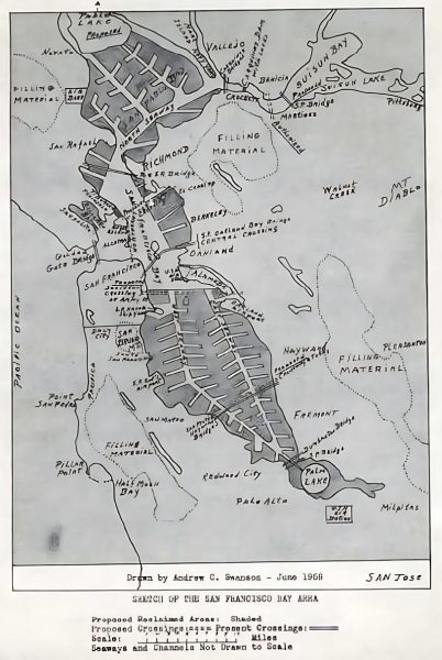
The drawing below shows one of the imagined, future visions of the Bay, which would have essentially filled ~90% of it to make room for development. The south end of the South Bay was imagined to be a freshwater lake, and all those little spurs would have been small canals between offices and housing, so the entire Bay might have looked like Foster City. Foster City is a great place to live and sail, but the Bay Area wouldn’t be the Bay Area if this plan had been followed.
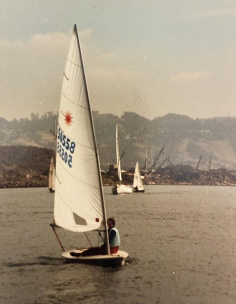
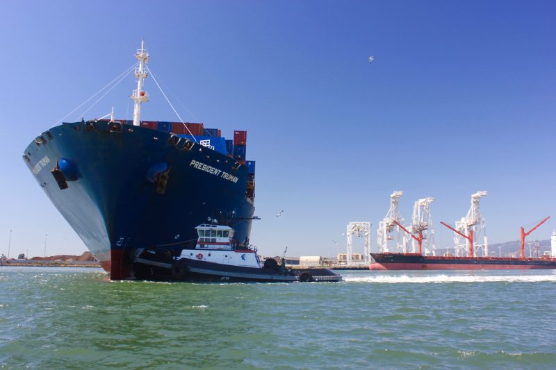
Thankfully, the preservation of the Bay allowed it to remain the biggest “park” in the Bay Area — one that continues to be used by sailors, swimmers, paddlers, surfers, fishermen, wing-sailors, Sea Scouts and, of course, lots of commercial activity. We learned more about the health of this watery park when we recorded a Good Jibes podcast with Peter Molnar, who sent us the photo below of him sailing a Laser in the Richmond Channel in the ’70s. It was a very dirty Bay/park back then. All those cranes and steel scrap piles were part of a very industrial shoreline that has been cleaned up over the past decades. Numerous individuals, agencies, government offices, nonprofits and the BCDC can take credit for saving and cleaning up the Bay.
One of the disturbing trends for our Bay park in the middle of the Bay is the reduction of access to the Bay. Over the years, marinas have closed, channels have silted up, launch ramps have deteriorated, and waterfront facilities have been converted from maritime use to alternative real estate development. While the BCDC has been an ally in cleaning up the Bay, it has often been an impediment to preserving access to the Bay. It’s currently actively doing the right thing by helping the enforcement of an Oakland Estuary cleanup, but it also seems to focus more on bike paths around the Bay rather than ramps, docks, marinas and facilities that support access to being on or in the Bay. That’s a terrible loss for the Bay Area community, and especially kids.
The original 1968 Bay Plan that formed the BCDC certainly envisioned providing access to the Bay and its shoreline when it wrote, “The Bay is the most important open space in the Bay region. The Bay and its shoreline provide unique recreational opportunities. Participating in recreation activities on the Bay and along its shoreline can inspire an appreciation of the Bay and can motivate people to participate in the responsible management and protection of the Bay. In 1963, only about four miles of the approximately 1,000-mile Bay shoreline were being used for waterfront parks. Since then, increased interest in the Bay has resulted in development of additional parks, marinas, and other forms of water-oriented recreation. But the full recreational potential of the Bay has by no means been reached.”
One of the conclusions reached in “Uses of the Bay” in the San Francisco Bay Plan says, “The most important uses of the Bay are those providing substantial public benefits and treating the Bay as a body of water, not as real estate.”
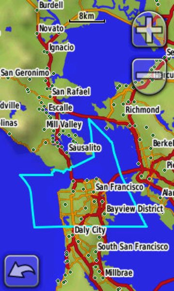
Looking at the map above, you can see that you might race most of the Three Bridge Fiasco within the true boundary of the city of San Francisco — it includes all the water inside the blue line. We continue to think the Bay is the most underappreciated “park” in the Bay Area, and it will continue to be more difficult and expensive to enjoy if the waterfront is primarily seen as a real-estate development opportunity, rather than a community-access opportunity. It is clear that development is necessary to maintain much of the shoreline’s deteriorating infrastructure, but the development needs to be balanced with preservation of both the recreational and commercial benefits of a thriving maritime culture. The Bay is more than something to look at or drive over. Beyond sailing, there is rowing, swimming, fishing and all the commercial traffic that provides international and local trade to the region.
While we continue to applaud the BCDC’s Bay cleanup efforts, we also continue to worry about the narrowing spaces that are available to launch a boat, store a boat, or get a kayak or SUP into and out of the water. Plus, both commercial and recreational boats need industrial space along the shoreline so boats can be serviced and maintained. The Bay is a miraculous resource that should be kept affordably accessible for the eight million people in the Bay Area. All current current and future users of the Bay need to stay attentive to the agencies and municipalities that have the ability to preserve access for all.
HERE HERE!
It is wonderful that the Sea Scout building in Palo Alto was restored after years of falling into disrepair. It is now the Eco Center and the restoration was a fantastic example of restoring some significant heritage. The original building was designed by Birge Clark, who designed many remarkable buildings in Palo Alto. I met him at his 50th Stanford Reunion and asked him if he remembered my Grandmother, a classmate of his. “Oh yes, twinkle toes”. I never knew. Anyway, all this is wonderful but why did they refuse to let the Sea Scouts use the new building to hold a meeting a few years back? That would have been so easy and a nice recognition of the heritage of the building. We need to have some serious discussions about our priorities as this wonderful article points out.
This can’t be overstated. One aspect is the increase in shoreline property values due to development that make working waterfronts – i.e. boatyards, fuel docks, etc untenable due to high rent. The marine industry has suffered greatly because of this, and fewer people enter the maritime trades that are needed for boat maintenance.
Well said! Thank you!