
The Mysterious Disappearing Island
With modern advances in science and technology, it seems that new things are always being discovered, be it a miracle drug, a cure for a disease or a previously unknown species. So it’s not every day when something gets “undiscovered,” but that’s exactly what happened earlier this month when a research vessel in the South Pacific went to look for Sandy Island (also known as Sable Island), shown to be located halfway between Australia and New Caledonia on Google Maps and on scientific — but not navigational — charts.
"We saw this mysterious island on all the scientific maps and weather maps but not on this one navigational chart that was on our ship," said Sabin Zahirovic, part of the research team aboard RV Southern Surveyor. "So we decided to go see if it was actually there."
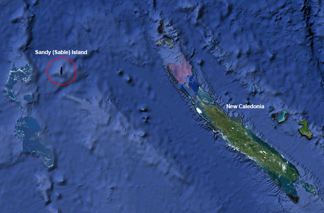
The research vessel, whose mission was to study tectonic evolution of the Eastern Coral Sea arrived at the island’s known position at night. The reserachers watched their depth finders and navigation equipment closely, but to their astonishment they found nothing but open sea. "The captain was actually quite nervous because the island was showing up on all the maps. Luckily for us the sea floor turned out to be very deep there”, added Zahirovic.
While the “un”-discovery was not part of the ship’s research mission, it’s very significant nonetheless. "All the scientific cartography relies on these maps, and numerical simulations of waves and currents depend on (the) size of these land forms," said Zahirovic. "It just goes to show the oceans are so underexposed. It’s actually really shocking that we haven’t not found more islands."
According to Jethro Lennox, publisher of The Times Atlas of the World (in which the phantom island had been featured at one time), "Back in the 19th century, cartographers would gather their information from various sources like explorers or even sailors, so you could never have a perfect map." Interestingly, the nautical navigation charts show nothing but deep water at the island’s supposed location.
This just goes to prove that while Google Maps might be great for quick planning purposes, you don’t want to use it for navigation!