“Inaccurate” Charts or Not?

©Latitude 38 Media, LLC
Following our Friday ‘Lectronic report on the loss of the Ventura-based Leopard 46 catamaran Tanda Malaika on a reef off Huahine in French Polynesia, allegedly because of inaccuracies in a Navionics electronic chart, we asked South Pacific veterans for their opinions of the accuracy of Navionics charts.
All charts of French Polynesia and the South Pacific, not just Navionics charts, are inaccurate, was the overwhelming response we got.
The one exception was from Alan and Laura Dwan of the Los Angeles-based Herreshoff 36 Nereia, who did the 2013 Pacific Puddle Jump and who are currently in Fiji.
“We use Navionics on our iPads and find it very accurate,” they write. However, their ‘first rule’ is, “We don’t sail at night when near any island. We heave to and wait until daylight.”
Alan also wonders if Navionics charts for iPads are more accurate than the Navionics version for chartplotters. “I have wondered about this, as virtually all of the reports of boats hitting reefs because of inaccurate Navionics charts were from boats using chartplotters and not iPads.”
Tanda Maliaka is currently at 16° 49′ 47" S, 150° 59′ 41" W, which is very close to but not exactly where she went aground, as she’s been pushed farther onto the reef by waves. We at Latitude, and a lot of others, would like to see what avionics and other charts show for those coordinates.
For everyone who wants to accuse the Govatos/Willis family — Danny and Belinda, and children Jude, Mycah, Aidan, and Emma — of being fools or incompetent, there are very experienced South Pacific cruisers who are cautioning not to judge so quickly. Among them are John and Debbie Rogers of the San Diego-based Deerfoot 62 Moonshadow, who also came close to going aground on a reef at Huahine. As they explain, there is a little more to reading electronic charts than some people think.
“On Moonshadow, we have Garmin chartplotters, Navionics charts on our iPads, various electronic charting available through the iNavX iPad app, three iPad apps that utilize Google Earth and/or Bing Satellite imagery, paper charts, and radar.
"We have found that, at times, all the navigation products are accurate. But, in the South Pacific we’ve also found that they sometimes disagree, and sometimes all of the charting products are laughably inaccurate.
"In Fiji, which has many reefs, we’ve found that the satellite imagery-based navigation apps are indispensable. But they have their limits, too, such as clouds right over the route you are planning to take!
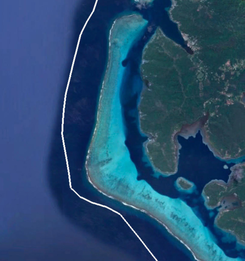
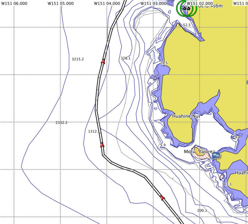
"The tragic end of Tanda Malaika’s passage to Huahine reminded us of our passage to Huahine last year. We had plotted a route that kept us outside the 300-foot depth contours, but as our GPS track shows in the accompanying graphic, we had to make an abrupt turn to port to give us more sea room around the reef that juts out from Huahine’s western shore.
"We only did this after my son asked if we weren’t getting a bit close the the surf line. We looked up, and to our horror found that we were only about 900 feet from the surf! Had it been nighttime, we almost certainly would have ended up in that surf.
"Despite all of our resources mentioned above, we had become a bit complacent, relying only on the Garmin chartplotter to plan the course for this passage. As the accompanying images show, Garmin shows depth contours of 200, 328, and over 600 feet — in the same area where we found 10-foot breakers!

©2017Latitude 38 Media, LLC
"To their credit, Garmin placed a thin dotted line where the reef exists, but users of the product only learn the meaning of the dotted line by hovering the cursor over the line, which calls up the warning ‘Danger Line’.
"How they get away with showing those deep depth contours inside the reef is beyond me.
"Our Navionics electronic charting does a better job of showing the reef, but we didn’t cross-check the route for this passage. But we wonder if this might not be the same place where Tanda Malaika came to grief.
"Two important reminders on this subject: First, many chartplotters will only show important hazards below a certain zoom level, so it is important to routinely zoom all the way into the closest scale, then back out.
"Second, the water on these reefs is usually just one wave deep, not the massive acreage of white water you typically find along California’s coastal surf spots. Viewed from seaward, these huge waves are blue, and do not look like surf until you’re in them or really close. And once you’re on those shallow reefs, it’s almost impossible to get off.
"Finally, let me share some advice I learned way back in 1971 from the legendary South Pacific skipper Omer Darr upon our arrival at Huahine aboard the 58-ft gaff schooner Fairweather: Never approach South Pacific Islands at night. Omer was an extremely experienced and respected schooner captain who’d made scores of trips to the South Pacific aboard big schooners such as Te Vega and Wanderer. Aboard Fairweather, Omer had us heave to well offshore in the lee of Huahine when we arrived before dawn. So aboard Moonshadow, we always plan our departures to arrive after sunrise. If we arrive at a destination too early, we’ll heave to rather than push on into an unknown anchorage.”
Update: Just before posting this ‘Lectronic, we received the following email message from Ted Simper of Roundabout II, who has been cruising in the South Pacific for several years:
"We are familiar with the reef where the catamaran went on the reef at Huahine. I feel very sorry for the family, but the reef is clearly and accurately shown on our up-to-date Navionics charts for the iPad. Even our 2011 version of Navionics on our C80 chartplotter seemed very accurate in French Polynesia. It certainly showed the reef in question off Huahine, so when we went by at night, we stood several miles off for safety."
We’ll have more on this subject, such as what can be misleading about electronic charts and how to use satellite imagery to check charts, in future ‘Lectronics and the September issue of Latitude 38.
