
The Grand Poobah, Hurricanes and the Baja Ha-Ha
Given the tropical storm activity off Mexico so far this month, many of you Ha-Ha entrants are naturally concerned. You would be foolish not to be. So let me, the Poobah, explain why I intend to start the Ha-Ha a week from next Monday, as scheduled.
As publisher of Latitude 38 for 40 years, I’ve had many occasions to cover severe tropical storm damage and to see the depressing aftermath. Such as the “ultimate hurricane hole” of Culebra, Puerto Rico, where over 300 of the 320 boats were completely destroyed by one hurricane. Or Village Cay in Tortola, where a 65-ft cruising cat ended up on top of a building, and over 800 boats nearby lost their masts.
I’ve also learned that the only thing worse than a destroyed boat is one that’s partially damaged and will likely take a long, long time to repair. I respect tropical storms.
As someone who has taken my boats to Mexico in November every year but one for the last 35 years, I’ve had a strong personal and financial interest in being aware of tropical storms and avoiding them.
Here are the reasons I plan to run the Ha-Ha on schedule:
1) Historically, hurricane season along Baja has shut down at the end of October for two good reasons. First, the atmospheric conditions stop being conducive to tropical storms. Note, for example, that air temperatures in Puerto Vallarta, 300 miles south of Cabo, are soon forecast to drop to as low as the high 50s at night. Tropical storms need temps over 82 to thrive. In addition, the water temperatures off Baja have begun to cool. Note that moderately strong, cool winds are forecast to blow down the coast of Mexico next week. Ask anyone in the Sea of Cortez what northerly winds do to water temperature. Also helping to thwart tropical storms is the fact that the days are getting shorter.
2) The official hurricane season in Mexico is from May to the end of November — but this is a little deceptive. There’s more than 1,000 miles of south-north on the coast of Mexico. If you were to break Mexico into two hurricane zones, one north of Cabo and one south, the season in the northern zone would end at the end of October. For the record, there hasn’t been a tropical storm that’s crossed the path of the Ha-Ha during Ha-Ha dates.
3) The fact that the Ha-Ha heads south, toward any possible tropical disturbance, is a major safety factor. All the fleet would have to do is stop at either Turtle Bay or Bahia Santa Maria to almost entirely eliminate the possibility of encountering a tropical storm. It just so happens that both Turtle Bay and Bahia Santa Maria/Mag Bay are good places to ride out bad weather no matter the direction.
4) There have been two times when the Poobah, based on the advice of professional weather routers, paused the Ha-Ha. One year we stopped for two days at Turtle Bay. Nothing came of it.
In 2019, based on professional weather routers, we suggested the members of the fleet deal with the possible approach of tropical storm Raymond in one of three ways. 1) Stay in Bahia Santa Maria/Mag Bay, which is what most of the fleet did. 2) Continue on to Cabo if they had a confirmed slip there. 3) Make the 175-mile trip south to Cabo, then continue another 135 miles up to La Paz. Several boats chose this option. Thanks to such a long lead time on tropical storm Raymond, the boats had no trouble making it to La Paz.
As it turned out, tropical storm Raymond didn’t come within 400 miles of Cabo San Lucas, and nearly 600 miles of the main fleet in Mag Bay. After it became a remnant depression, it dumped a ton of rain on southern Baja and brought about 20 knots of wind to some places. That was it.
5) As the Grand Poobah, during the Ha-Ha I constantly monitor PredictWind, PassageWeather, Windy, and other sources for tropical storms. But I go beyond that. Each day of the Ha-Ha I consult with Commanders’ Weather to see if the conditions are conducive to the formation of a tropical disturbance. Since disturbances almost always form way down by the Mexican border with Guatemala, that would normally give the fleet at least a seven-day warning of a possible, but not necessarily even probable, tropical storm.

There are no guarantees in cruising — or life — but I hope I have presented why I plan to start the Ha-Ha on schedule.
By the way, Assistant Poobah Patsy just spoke with Jesus at Marina Cabo San Lucas. While he hasn’t had time to do a complete inspection, it appears there hasn’t been significant damage. There has been lots of flooding, of course, and the electricity is still out. But we’ve been through this Cabo post-hurricane movie three times before, and they know how to bounce back.
We haven’t personally heard from all the marinas in La Paz, but our understanding is that only the so-called “virtual marina” had boats that suffered significant damage. [See today’s ‘Lectronic Latitude report on Hurricane Norma.]
Over on the Caribbean side, what was once Cat 3 Tammy got weird, and after hitting Barbuda with 80 knots, totally whiffed on all the other islands in the northeast Lesser Antilles.
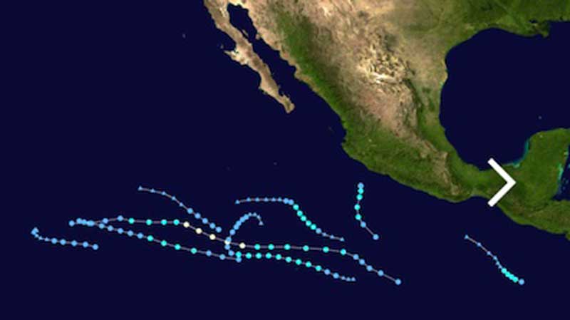
Graphics: Anybody see a pattern to post-season tropical storms in Mexico? Such as their all being at least 500 miles to the south of Cabo and most of them moving out to sea?
Excelente!
To be clear, tropical storms derive their energy from the sea surface temperature and not the air temperature. They require sea surface temps of 80°F/27°C or higher (some sources put the number at 79F). Surface aIr temperature is a minor factor in tropical storm formation. Current sea surface temperatures around the Cape on 22 Oct are about 29C (La Paz and Cabo).
The extremely rapid intensification of Hurricane Otis (winds increasing over 110 mph in 24 hours) far surpassed any tropical storm event ever experienced in Mexico. As a comparison, the standard definition of rapid intensification is wind speeds increasing by 35 mph in 24 hours. I think Otis shows us that, because of climate change, we are living in a very different meteorological world. Future tropical storm conditions can no longer be counted on to follow historical patterns.
The BaJa Ha-Ha is one of my wonderful memories sailing with my friends on s/y Solar Planet from San Francisco to All the way to Puerto Vallarta. I thank Richard (of Latitude 38) for have put such a great venue on.
I have required myself to do it one more time having sailed all over the world for over 50 years, which has been a priviledge.