
Earl in the Eastern Caribbean
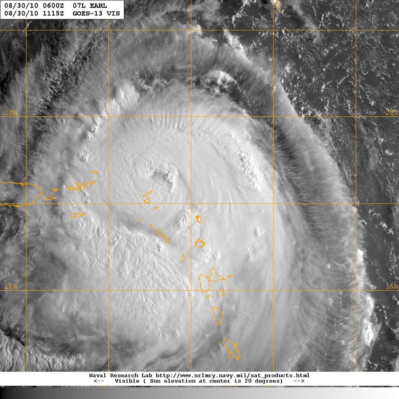
While the East Coast of the United States eyes the approach of Earl, now a Category 3 hurricane, the northern islands of the Eastern Caribbean are trying to clean up the damage wrought by Earl when he came through Sunday afternoon through Monday night as anything from a Category 1 to a Category 4 hurricane — the latter meaning winds to 135 knots. Meanwhile, they are keeping an eye on Tropical Storm Fiona, which is now hitting some of them with winds to 55 knots. A poorly formed storm, Fiona will hopefully be out of everyone’s hair in a day or two.
Earl began her WNW sweep of Antigua, St. Barth and St. Martin looking to be a poorly defined Category 1 hurricane, and not that serious, in part because she would be leaving the islands to the southwest, the quadrant where the winds would be the weakest. But in short order Earl jumped to a Category 2, then 3, then 4 hurricane.
©2010 Latitude 38 Media, LLC
At least as bad, he not only developed a very tight and defined eye, but by the time he passed just to the north of the British Virgins, he was something like 200 miles across. The latter would be a critical factor, because it meant that the British and U.S. Virgins would not just get hit by hurricane force winds out of the north, northwest and west, but also trailing hurricane force winds out of the southwest and south. Road Town, the huge charterboat center of Tortola that is home to The Moorings and other charter companies, is a bay naturally protected in all directions but the south.
Even two days after Earl passed through, it has been difficult to get a good assessment of the damage to boating interests in the northern Leewards. The problem is that there are so many different islands and no common language or place to report the damage. But based on news reports and blogs, it seems certain that the damage wasn’t anywhere near as bad as it could have been. The big sailing centers of Antigua and St. Martin got hit before Earl had fully developed, and apparently did well. It’s less certain if that’s the case at St. Barths, where we’re told mariners were advised to expect just 40 knots, but then got hit by well over 100 knots.
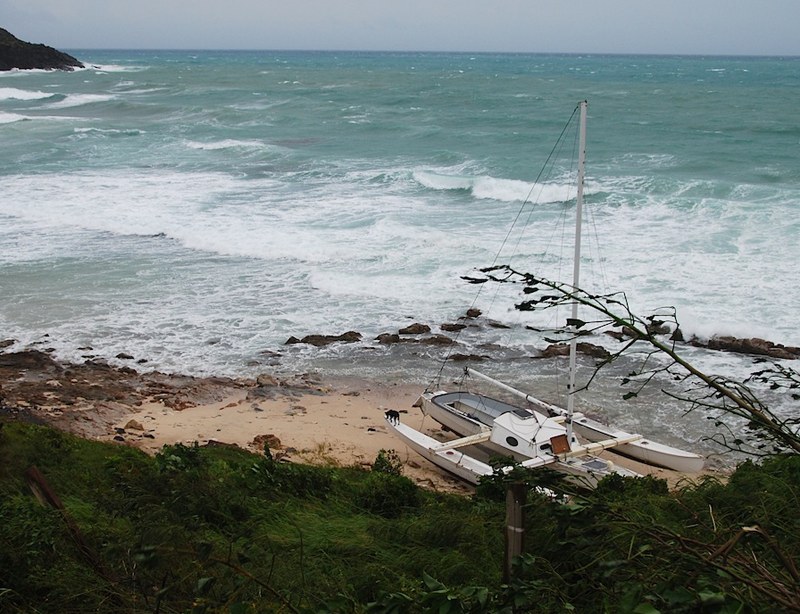
Almost certainly the island that suffered the most was Anegada, the very low island in the northeast part of the British Virgins, and therefore probably closer to Earl‘s eye than any other. Hopefully all the boats were taken away prior to the storm, but much of the boating and other infrastructure was apparently destroyed. Our hearts go out to all the special people on that remote island.
On the brighter side, the damage at mountainous Virgin Gorda was said to be surprisingly light. For example, the big boatyard at Spanishtown reported that no boats fell over on their cradles.
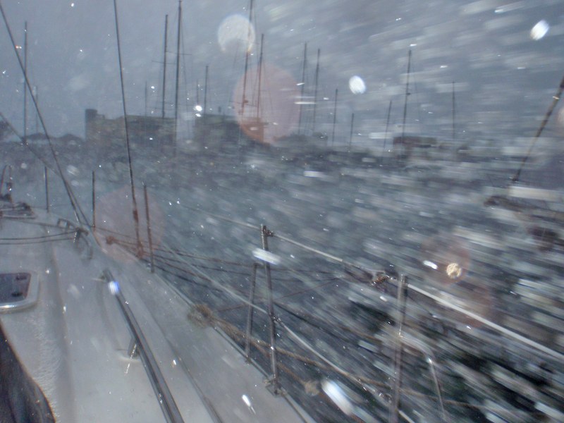
The big question was always going to be what happened to Tortola, the charterboat center of the universe, and home to lots of other boats, too. Initially, things looked really good. Although the hurricane was very strong and the eye only about 70 miles away, the high island would provide a natural shield to all the boats on the south side. Indeed, things were going much better than could be expected until the winds started to come out of the west, at which point a number of boats and facilities were damaged or destroyed at Soper’s Hole in the West End. As the eye of Earl pulled away, however, the wind started coming out of the southwest and south.
© Latitude 38 Media, LLC
The following is an eye-witness report from a frequent Latitude contibutor who doesn’t want his insurance company to know he’s in the Virgins and not 400 miles away and outside of the hurricane zone in Grenada:
"I rode out Earl at the Village Cay Marina on the south side of Tortola. The two sets of wind instruments atop my 70-ft mast read a constant 74-78 knots for three hours at the worst of it, with a maximum gust of 86 knots. I had removed everything I could from the outside of my boat, and was secured by 12 strong lines and an anchor. While there were lots of downed trees and power lines, and no lights at night, my boat wasn’t damaged. In fact, there was no damage to any of the 25 other boats in the marina. However, there has been lots of damage to boats anchored out and moored out, including some large commercial vessels. The boats at The Moorings appeared to have done fine, but some sails had unfurled and some awnings at the base were damaged.
"Earl started with winds from the northwest at 45 to 48 knots, but by 10 p.m. on Monday night, the wind backed 90 degrees to the southwest and then the south. Within an hour, the wind was coming out of the south at over 70 knots, and everyone who had secured their boats for northwest winds scrambled to adjust their lines for winds from the other direction. We got our strongest wind from the south, not the north, and that caused most of the trouble to the anchored and moored boats."
It’s unclear what damage there was at Jost van Dyke, home to Foxy’s. After it was reported that the Bomba Shack on the north shore of Tortola had been destroyed, there was much grieving on the internet. Then it was reported it hadn’t been destroyed at all. Everyone was advised that the next full moon party would go on as scheduled, and that magic mushrooms are still perfectly legal in the British Virgins.
©2010 Latitude 38 Media, LLC
As for St. John and St. Thomas in the U.S. Virgins, the news seemed to be good. As with all the other islands, there were surely scattered boats that were damaged or destroyed, but not a wholesale disaster.
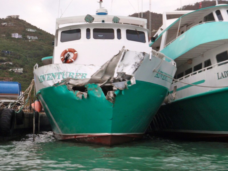
As previously reported, the owner of Latitude 38 has a Leopard 45 cat in a yacht management program with BVI Yacht Charters based out of Port Purcell, Road Town, on the south side of Tortola. We were initially quite confident our cat would be safe, what with her being in the weakest quardrant of the hurricane and having a high mountain between the eye of the hurricane and our boat. But after hearing nothing all day yesterday, and then learning of the surprise hurricane force winds out of the south, we began to get concerned. In the wee hours of last night we received photos of large commercial vessels stacked up at what we believed was the breakwater at Port Purcell, and we became really concerned.
We need not have. Halfway through writing this report, we spoke with a cheery Abby at the BVI base. "Oh no, everything’s fine with all our boats and with your cat," she reported in the most chipper voice possible. "In fact, ‘ti Profligate is going out on charter tomorrow."
Whew! Now if we and everybody else can just get through the rest of the hurricane season, which has suddenly gotten busy in the Atlantic/Caribbean.