
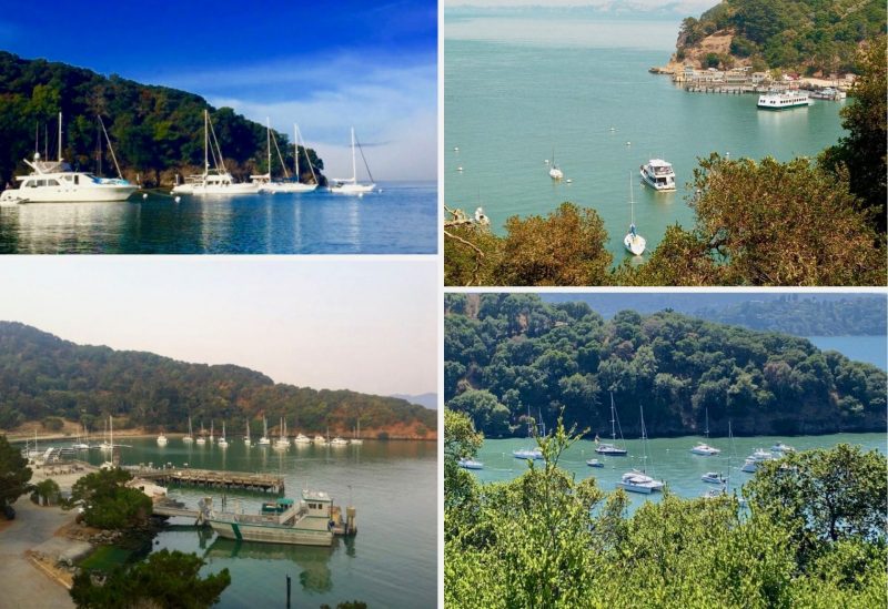
How Deep Do the Waters Run in Angel Island’s Ayala Cove?
For years now, we’ve heard that Ayala Cove has become too shallow for bigger, deeper-draft sailboats. Readers have asked us what we’ve heard about dredging around Angel Island, which is part of the California State Parks system.
“Currently, we have no plans to dredge Ayala Cove,” a State Parks spokesperson told us in an email a few months ago. “The mooring field and docks have been full almost every weekend, so this is news to us,” the spokesperson said, referring to our assertion that many people told us that Ayala had become too shallow for some boats.
“I’m aware some of the larger sailboats — 36-ft-plus, depending on draft — may have issues at low tide,” the spokesperson said.
“All deferred large maintenance projects, which would include dredging the cove, compete statewide with other projects,” the spokesperson added. “For example, the repairs currently being planned for docks were awarded last year through the statewide selection process.”
We need to hear from you, Latitude Nation, and so too does the park service. Dredging and the general maintenance are matters of persistent advocacy — what some would call good-willed harassment — in order to speak up for the things that we as boaters need.
What’s been your experience with Ayala Cove over the years? How big is your boat? What parts of the cove can you and can’t you use, and on what tides? Was the cove navigable in the past — say 5, 10 or 15 years ago — but no longer is?
Please be as specific as possible.
Here’s a personal anecdote from Latitude owner and publisher John Arndt. Using two boats over the years — a Ranger 33 with a five-foot draft, and now a Sabre 38 with 6.5-ft draft — John has hit the mud a couple of times approaching the docks, and not even at dead-low tide. “I now have a depthsounder, and I never knew it was that shallow!”
We hope to present the park service with some “data” that inform an area of need.
A few readers have noted that the ferries on Angel Island churn up the mud, causing silting in the shallows, though for now, that’s neither here nor there. Let’s identify the symptoms first, and then consider the causes.
Please write us below, or email us here with your anecdotes.
We are frequent visitors to the Ayala Cove mooring balls on our Pearson 36-2 and it’s a great experience. But while on my kayak this last year I did take a lead line around to each ball at dead low tide and it ranged from 4’11” to 5’1. Plan on the tide coming and going and no problem.
We have been going to Ayala Cove for many years. The EYC has at least one cruise out per year to Angel Island. We are dark-siders now, and our Nordic Tug 42 only drafts around 5-Feet. The NT42 seems to be golden @ anything over MLLW. Our Slocum 43 Cutter had a draft of 6.6 feet and I can confirm the middle of the mooring field has silted in a lot over the years. It was problematic going there at anything near a low tide, and we were ‘dredging’ at MLLW, making maneuvering for the buoys interesting. The bottom is super soft. Try to come in on high slack water, preferably on days with minimal tide changes. If you “hit” the bottom while moored, it is very soft. If your draft is over 6-feet, stay to the moorings on the outside edges.
This is so frustrating. I ask a park ranger about this every time I visit Ayala. All the rangers know the cove is super-shallow and I’ve been told multiple times that the park service is aware but that no budget has been allocated for dredging. It sounds like feedback isn’t getting passed up the line.
Merope is a Baltic 38 that draws 7.25′. In our experience, we need +1.5′ tide to get into and out of the docks facing west. The docks facing east are a no-go at anything other than a +2.5′. The mooring field is deepest close to the beach (perhaps 5-6′ at a zero tide) and super shallow in the center (1.5-2.5′ at a zero tide). The moorings close to Raccoon Straight are not quite as deep as those close to the beach.
There have been SO MANY TIMES we’ve wanted to stop at Ayala, either to dock or pick up a mooring, but can’t because the cove is too shallow. The silver lining is that the bottom is soft mud, so if you can get in before the water goes out, you’ll be fine until it comes back in.
The Navionics app can create a layer of bathymetry taking into account the forecasted tide level if the device it’s running on is connected via NMEA to a depth sounder. I took advantage of a very high tide once to criss-cross the entire field to get an accurate chart. Unfortunately, that layer was lost when I had to replace my phone.
And the mooring field is hardly ever full that I’ve seen (usually just on holiday weekends), but the docks do fill up. At least the ones that are open. The last time I was there I think I counted 5 or 6 docks that were closed because the pilings have rotted and fallen away.
I used to enjoy mooring at Ayala Cove about ten years ago…but even then, we were firmly in the mud in a moderate low tide. Now, I don’t even think about mooring my Elliott 1050 anymore…it is way too shallow.
I draw 7′. This is too bad because I love the island and wish I could enjoy it my mooring there.
In our Catalina 36 (5.5’ draft) we find you can’t get to the middle moorings at MLW due to silting, but agree the mud is soft and harmless once you’re in. We have heard the outer rings of moorings are deeper due to tidal scour, but haven’t tested it yet. We agree the Rangers know very well how shallow it is, but shake their heads at the possibility of getting money for dredging. Their higher priority seems to be docks as that is where they spend more time and energy.