
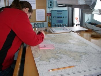
Bye Bye to Paper Charts
Paper is so passé — at least according to the federal government. NOAA announced earlier this week that the Federal Aviation Administration, the government agency that prints maritime charts, will cease printing them after April 13, 2014. Before you freak out, take a deep breath and keep reading.
The charts, which will continue to be updated by NOAA, will be still be available for purchase at shops with print-on-demand capabilities — Waypoints in Oakland and West Marine, for example (see OceanGrafix for a full list of worldwide retailers) — and the maximum price is set by the government to ensure affordability.
Digital chart files have been available for some time in ENC and raster formats, but NOAA has launched a trial program that will make them available in PDF format through January 22. If the response to the trial is positive, NOAA will likely continue the service. Read the FAQ sheet on the announcement HERE and download the free chart files HERE.
Of course modern chartplotters have made paper charts all but obsolete, but we personally would never leave on an extended voyage without a pile of paper back-ups. Electronics are known to fail at the most inconvenient times and we’d hate to have to enter port using the Braille method.
Besides, we have a certain fondness for paper…
©2013 Latitude 38 Media, LLC