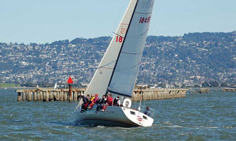
Is There a Safe Break in the Berkeley Pier?
Reader Alek Shestakov of the Sabre 34 MkII Kokopelli, berthed in Emeryville, wrote to ask, “Can you inform your readership about the status of the dilapidated portion of the Berkeley Pier? I refer to the mainly underwater, 1.9-mile-long section west of the 3000-ft extension from the Skates restaurant. Can vessels cross it anywhere?”

We reached out to Max Ebb, who replied, “Only one gap in the pier is known to be navigable: the easternmost gap, about 3,000 feet from the shore. This is at the west end of what used to be the habitable fishing pier.
“There are many other gaps and some large missing sections in the abandoned pier ruins farther west, but I’m not aware of any survey that locates another safe passage or identifies broken-off, invisible pilings that might be a serious hazard.
“The piling spacing is 16 feet, if I remember correctly. Some boats have made the mistake of assuming that a double-wide gap is safer, but have sunk after hitting the invisible piling in the middle of the double gap. See the old Diane Beeston photo of a Soling, I think it was, sunk on the Olympic Circle after getting this wrong.
“BTW the pier is a great knotmeter. Count how many pilings go by in 9.5 seconds, and that’s your ground speed in knots.”

There are DEFINITELY no safe gaps in the pier, and only one that is merely risky – the one by the end of the fishing pier. As a long time sailor out of the Berkeley Marina, I recommend against even using the apparently safe cut between the fishing pier and the ruins. If you simply MUST use it, stay well toward the fishing pier side. There is a debris pile of submerged remains of the ruins that were removed to make the gap just to the southwest of the gap. If you are coming from the marina side headed toward Emeryville, definitely resist the temptation to come to weather just outside that gap as you will go straight into the submerged debris pile.
I’ve seen a boat or two go safely through a gap fairly close to land but I’m quite happy to stay clear. I’m also not one to follow sheep over a cliff either.
I’ve passed dozens of times just outside the existing portion of the pier in keelboats drawing 6 feet. According to Navionics (and I realize this, as well as my report, is merely anecdotal): “A channel through the old pier ruins exists here at the end of the community fishing pier. Depth at low tide unknown but believed to be about 5 feet. Use caution and consult additional local knowledge before attempting this passage. Depth in the pass was reported in 2014 to be the same as in the surrounding waters, about 7 feet MLW.”
More importantly what can we do to make the opening larger and maybe add proper markers? What is the process to things like this done.
Call the Berkeley Marina office, 510-981-6740, Monday through Fridays 8:00 a.m. to 4:00 p.m., or Saturdays 8:00 a.m. to 4:00 p.m.
Max says “known to be navigable” and there are countless people who have gone through that opening in boats with drafts up to 7 feet, that I know about. BUT what debris/ruins are there, and what would the min depth be at MLLW?
It would, indeed, be cool, if someone dove the break, or properly sounded at/near MLLW.
We shot that first gap regularly on Resolute, draft 4′ and change. I think I was generally biased to be more cautious at lower tide and go around, but we never had any issues. Would be cool if someone could hit the area with high res sonar or dive it!
Hi Max, Yes, that is a Soling in the famous Beeston photo. It was taken during the Soling Olympic Trials in 1972, on the Berkeley Olympic Circle. According to the PRO, the wind speed ranged between 25 and 35 kts throughout the regatta. The sea state was square chop 4-6 feet. This Soling flooded and sank after a wild broach to weather.
The Berkeley pier was not a factor.
All of the Berkley Pier pilings should be removed because they are hazards to navigation. Bridge piers over rivers are removed to prevent underwater entrapments. “Save the Bay” money can fund the pile removal and restoration of the bay.
Sailed through the eastern most gap several times. It’s where I learned how to account for leeway.
I’ve gone through the gap at the end of the fishing pier in my 30′ sailboat that drafts 4.5′. It was uneventful, and saved a bit of upwind work going around the west end to the channel marker.
I too wish the passage were properly sounded and marked. Getting rid of the whole set of the pier ruins would be ideal, but I expect there’s no budget for that. Sounding and marking the cut seems like it should be doable with a reasonable cost.