Lane Shift Ahead
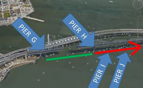
As of Monday, CalTrans had cleared the main channel of the old and new east spans of the San Francisco-Oakland Bay Bridge between piers G and H. This is the main channel span closest to the east side of Yerba Buena Island.
Since the demolition of the old cantilever bridge began, vessels have been detoured through a safety zone farther east between piers I and J. "Vessel Traffic Service San Francisco is advising waterway traffic to transit the main channel span G-H," writes David Sulouff, the bridge administrator. "The green center span lights previously in the I-J span have been discontinued. The green center span lights in the main channel span G-H have been activated."
The bulletin advises all watercraft to avoid navigating under the old bridge from pier H to the Oakland shoreline due to the dismantling of the bridge above. A safety zone will be established soon that will prohibit transit under the new demolition area.