
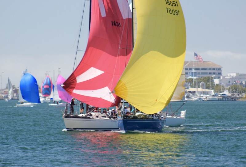
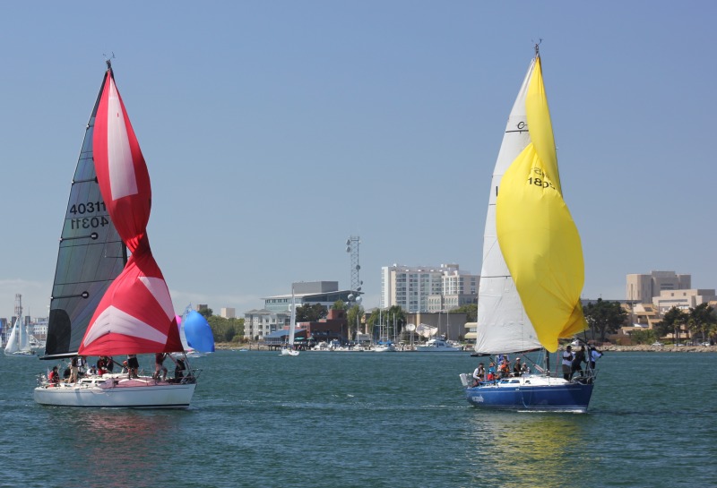
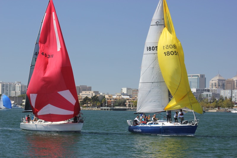
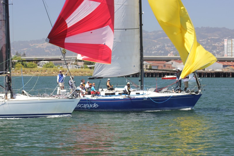
Photo Finish at 2nd Half Opener
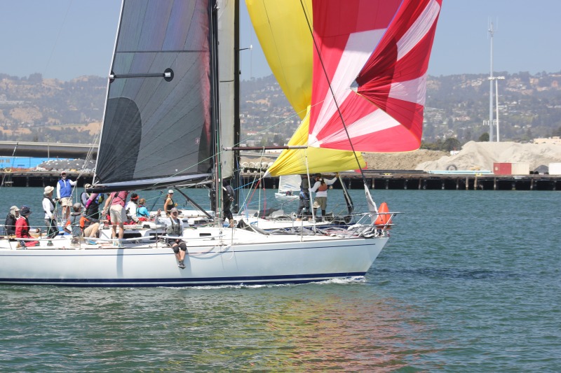
The 2nd Half Opener saw a dramatic photo finish on Saturday, as two Express 37s were neck and neck on the Oakland Estuary in the final stretch to the finish line in front of Encinal Yacht Club. Nick Schmidt’s Escapade got aggressive, using their leeward advantage to take up Laurence Baskin’s Bullet before the final jibe to the line. But both boats struggled to fill their spinnakers. Bullet got it sorted while Escapade’s yellow kite was slightly twisted on the forestay, as both boats careened toward the line just inches apart. At the docks, sailors watched the duel while sipping cold beers and oh-ing and ah-ing at the spectacle.
For full results of the 2nd Half Opener, be sure to pick up the September issue.
©2017Latitude 38 Media, LLC
©Latitude 38 Media, LLC
©2017Latitude 38 Media, LLC
©2017Latitude 38 Media, LLC
©Latitude 38 Media, LLC
A Research Vessel in a Bottle, Part II
On Friday, we told you about a small, unique remote control sailboat that we found on Rodeo Beach last week. The boat — named Edgar — was a customized RC Laser, which was about three feet in length, and equipped with solar panels, a small sail and an engine.
Seeing that the boat was designed for scientific research purposes, Latitude’s Mitch Perkins rescued the stranded vessel from the surf and brought to our office in Mill Valley. Edgar’s owner, Matthew Sanner, immediately tracked his little drone via a GPS transponder, gave us a call and showed up on Friday to retrieve his sailing robot.
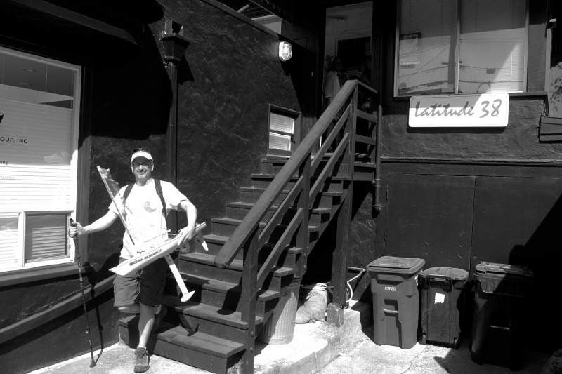
©Latitude 38 Media, LLC
Sanner is a sailor, works in IT (information technology) and calls himself a citizen scientist and a ‘maker’, which could be considered synonymous with inventor (‘Maker’ is part of "a contemporary culture representing a technology-based extension of DIY culture, and revels in the creation of new devices as well as tinkering with existing ones," said Wikipedia). He’s called his venture Pacific Bots, and started a blog.
Sanner hopes that his simple, inexpensive design can ultimatly be used as an affordable tool to collect an abundance of marine data, and hopes one of his boats will sail all the way to Hawaii one day, Sanner told us on Friday.
"I used to own a Cal 20 and sailed out of Coyote Point. But when my son was born, I had to give up the boat. But the love and desire for sailing have never gone away."
Sanner said that in 2013, he started programming Arduino microcontrollers, which is an open-source platform used for building hobby electronic projects. With some programming help from his brother, Sanner eventually came up with the idea for Edgar.
"I wanted to get back into the water," Sanner said, adding that he didn’t want to simply send a remote control boat into the ocean just for the sake of doing it. He wanted the boat to have a mission.
"I’m evolving the ethics that goes into this project," Sanner said. "What if the boat could bring back something of value to the scientific community? I love the whole autonomous thing, I want to build more boats, because they’re easy to build."
Edgar, which is a prototype for what Sanner hopes will be a fleet of similar vessels, has the ability to take temperature and pH readings, and send the data back to shore via satellite. Sanner said his small drones can potentially search for dead zones in the ocean. He also said that the price (and small size) of the robots lends itself to inexpensive data collection.
You might be wondering how the boat sails. Sanner reduced the size of the mainsail because Edgar was easily overpowered. The mainsheet slides on a fixed traveler, and a tight reach is the boat’s ideal point of sail.
"The rudder and autopilot have trouble holding course, and what typically happens is it rounds into the wind, then sails on again and self corrects. Hence the smaller sail," Sanner said. While ideal for wind over 10 knots, the small rig makes it difficult for Edgar to penetrate the surf when Sanner launches the boat for its missions (Edgar has been on two test sails so far, the second of which ended in our finding it).
So Sanner equipped Edgar with a ‘motor’ to punch through the surf zone. "It’s a 1000-gallon-per-hour bilge pump [fitted with a propeller]. It cost like, $30 off the shelf."
Sanner said when he launched Edgar from Stinson Beach last week and it was motoring out to sea, it almost got caught by a set. "I wish I’d got pictures of it," Sanner said. "It was like the scene on Moana when her canoe goes flying off the wave."
August Racing Preview
Among the exciting regattas coming up in the month August, we’re particularly paying attention to the following.
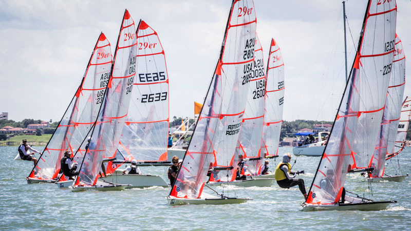
The 29er World Championship is being hosted by Alamitos Bay Yacht Club in Long Beach today through August 5. Teams to watch and cheer for include US Sailing Youth Worlds team members Neil Marcellini and Ian Brill from Richmond YC; they just placed eighth out of 116 entries. Many more teams hail from the West Coast; chances are you know one of the racers. Good luck to our local heroes! The 29er is the skiff of choice for teenagers.
Tiburon YC’s Moseley Regatta will be sailed on August 5. "We’re inviting the Etchells class in addition to all the CBRA classes," writes Cam Tuttle, race chair for TYC. "We’ll be running RC from the water and dropping temporary marks for W-L courses. Complimentary BBQ (probably oysters again!) and snacks after racing; guest berthing is available with advance notice (email me)." Many of the same competitors will sail the next day at the YRA’s CBRA #3 hosted by Corinthian YC; skippers might contemplate keeping their boats in Tiburon for the weekend. Speaking of the YRA, the YRA Series will conclude on Saturday in the Southampton Shoal racing area.
Lake Washington Sailing Club’s Dinghy Delta Ditch will run from Rio Vista up the Sacramento River Deep Water Channel to Lake Washington on August 5. Sign up today to save yourself the $15 late fee. Food, music and partying await in West Sacramento.
Armchair sailors might enjoy following the Rolex Fastnet, which starts on August 6. Of the 390 boats entered, 338 will compete for the main IRC handicap prize; the remainder will race for their own trophies in the Class40, IMOCA 60, Volvo Ocean 65 and Multihull grand prix classes. The line-up includes boats from 25 nations. Are any of our West Coast readers going? If so, we’d love to hear from you.
Balboa YC in Newport Beach will host the 60th Anniversary Lido 14 National Class Championship on August 11-13. Will Larry Ellison attempt to recapture glory in the class of his youth?
The OYRA and SSS will again join forces for the Drake’s Bay Race on August 12-13. CYC will provide the race committee for the start in Tiburon and finish in Point Reyes on Saturday, and vice-versa on Sunday. In between, racers will spend the night on the hook in scenic Drake’s Bay.
Monterey Penisula YC will host the Mercury Nationals on August 25-27.
Sausalito YC’s Women Skippers Regatta on August 26 is timed to coincide with National Women’s Day. All-women and coed crews are welcome, but no man’s hand may touch the helm. It will be a full day with breakfast at the skipper’s briefing. A single race with multiple PHRF divisions and courses will be tailored to accommodate the boats entered. A live band and a BBQ will round off the day.
Did we skip your favorite August regatta? No slight intended; we’ve simply reached the end of today’s space/time continuum. Drop us a line and tell us a little about it.
“Inaccurate” Charts or Not?
©Latitude 38 Media, LLC
Following our Friday ‘Lectronic report on the loss of the Ventura-based Leopard 46 catamaran Tanda Malaika on a reef off Huahine in French Polynesia, allegedly because of inaccuracies in a Navionics electronic chart, we asked South Pacific veterans for their opinions of the accuracy of Navionics charts.
All charts of French Polynesia and the South Pacific, not just Navionics charts, are inaccurate, was the overwhelming response we got.
The one exception was from Alan and Laura Dwan of the Los Angeles-based Herreshoff 36 Nereia, who did the 2013 Pacific Puddle Jump and who are currently in Fiji.
“We use Navionics on our iPads and find it very accurate,” they write. However, their ‘first rule’ is, “We don’t sail at night when near any island. We heave to and wait until daylight.”
Alan also wonders if Navionics charts for iPads are more accurate than the Navionics version for chartplotters. “I have wondered about this, as virtually all of the reports of boats hitting reefs because of inaccurate Navionics charts were from boats using chartplotters and not iPads.”
Tanda Maliaka is currently at 16° 49′ 47" S, 150° 59′ 41" W, which is very close to but not exactly where she went aground, as she’s been pushed farther onto the reef by waves. We at Latitude, and a lot of others, would like to see what avionics and other charts show for those coordinates.
For everyone who wants to accuse the Govatos/Willis family — Danny and Belinda, and children Jude, Mycah, Aidan, and Emma — of being fools or incompetent, there are very experienced South Pacific cruisers who are cautioning not to judge so quickly. Among them are John and Debbie Rogers of the San Diego-based Deerfoot 62 Moonshadow, who also came close to going aground on a reef at Huahine. As they explain, there is a little more to reading electronic charts than some people think.
“On Moonshadow, we have Garmin chartplotters, Navionics charts on our iPads, various electronic charting available through the iNavX iPad app, three iPad apps that utilize Google Earth and/or Bing Satellite imagery, paper charts, and radar.
"We have found that, at times, all the navigation products are accurate. But, in the South Pacific we’ve also found that they sometimes disagree, and sometimes all of the charting products are laughably inaccurate.
"In Fiji, which has many reefs, we’ve found that the satellite imagery-based navigation apps are indispensable. But they have their limits, too, such as clouds right over the route you are planning to take!
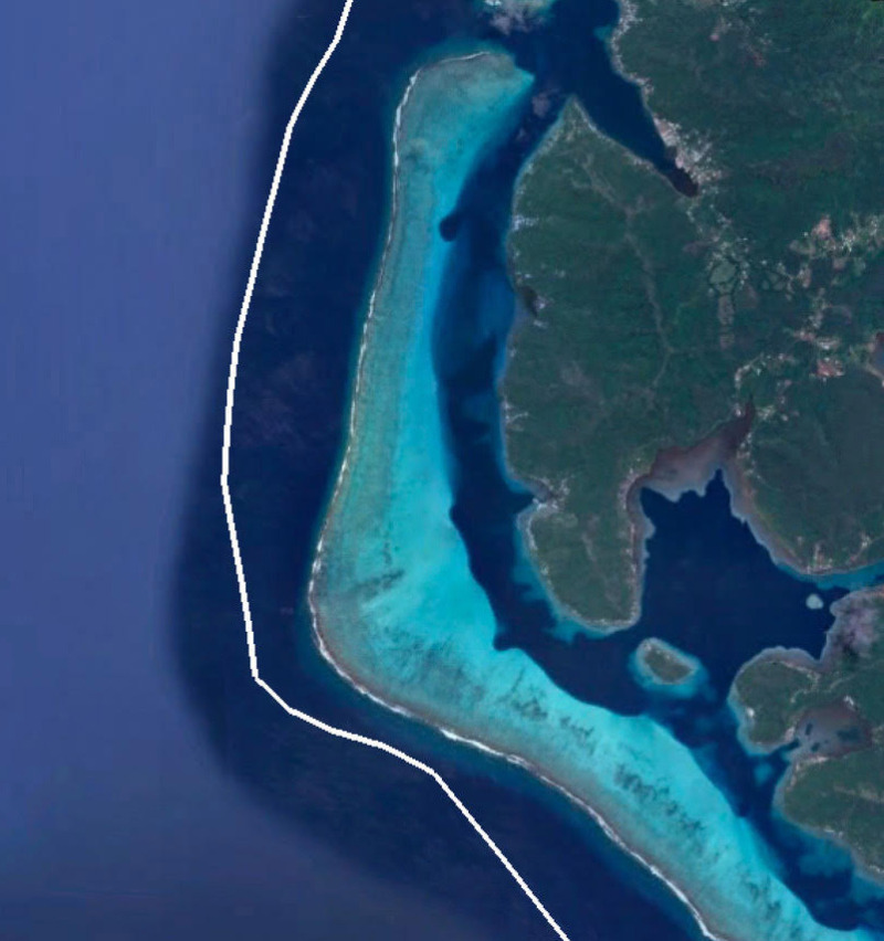
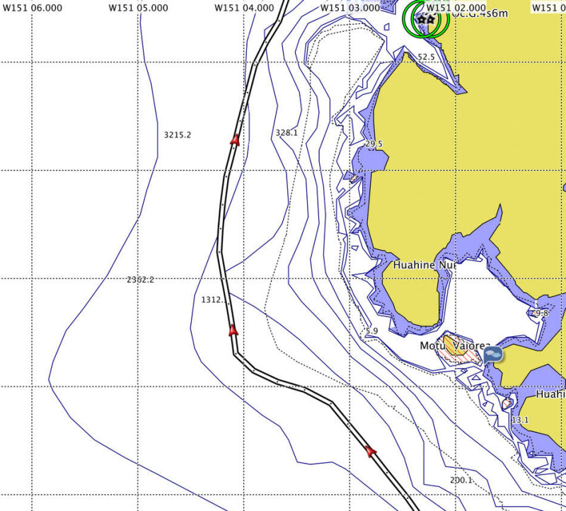
"The tragic end of Tanda Malaika’s passage to Huahine reminded us of our passage to Huahine last year. We had plotted a route that kept us outside the 300-foot depth contours, but as our GPS track shows in the accompanying graphic, we had to make an abrupt turn to port to give us more sea room around the reef that juts out from Huahine’s western shore.
"We only did this after my son asked if we weren’t getting a bit close the the surf line. We looked up, and to our horror found that we were only about 900 feet from the surf! Had it been nighttime, we almost certainly would have ended up in that surf.
"Despite all of our resources mentioned above, we had become a bit complacent, relying only on the Garmin chartplotter to plan the course for this passage. As the accompanying images show, Garmin shows depth contours of 200, 328, and over 600 feet — in the same area where we found 10-foot breakers!
©2017Latitude 38 Media, LLC
"To their credit, Garmin placed a thin dotted line where the reef exists, but users of the product only learn the meaning of the dotted line by hovering the cursor over the line, which calls up the warning ‘Danger Line’.
"How they get away with showing those deep depth contours inside the reef is beyond me.
"Our Navionics electronic charting does a better job of showing the reef, but we didn’t cross-check the route for this passage. But we wonder if this might not be the same place where Tanda Malaika came to grief.
"Two important reminders on this subject: First, many chartplotters will only show important hazards below a certain zoom level, so it is important to routinely zoom all the way into the closest scale, then back out.
"Second, the water on these reefs is usually just one wave deep, not the massive acreage of white water you typically find along California’s coastal surf spots. Viewed from seaward, these huge waves are blue, and do not look like surf until you’re in them or really close. And once you’re on those shallow reefs, it’s almost impossible to get off.
"Finally, let me share some advice I learned way back in 1971 from the legendary South Pacific skipper Omer Darr upon our arrival at Huahine aboard the 58-ft gaff schooner Fairweather: Never approach South Pacific Islands at night. Omer was an extremely experienced and respected schooner captain who’d made scores of trips to the South Pacific aboard big schooners such as Te Vega and Wanderer. Aboard Fairweather, Omer had us heave to well offshore in the lee of Huahine when we arrived before dawn. So aboard Moonshadow, we always plan our departures to arrive after sunrise. If we arrive at a destination too early, we’ll heave to rather than push on into an unknown anchorage.”
Update: Just before posting this ‘Lectronic, we received the following email message from Ted Simper of Roundabout II, who has been cruising in the South Pacific for several years:
"We are familiar with the reef where the catamaran went on the reef at Huahine. I feel very sorry for the family, but the reef is clearly and accurately shown on our up-to-date Navionics charts for the iPad. Even our 2011 version of Navionics on our C80 chartplotter seemed very accurate in French Polynesia. It certainly showed the reef in question off Huahine, so when we went by at night, we stood several miles off for safety."
We’ll have more on this subject, such as what can be misleading about electronic charts and how to use satellite imagery to check charts, in future ‘Lectronics and the September issue of Latitude 38.