Skip to content

July 23, 2003


Photo of the Day

July 23 – Caribbean Sea

Today’s Photo of the Day is of the Ocean
71 Second Life – veteran of the first Whitbread Around
the World Race – as seen during the second leg of the 2001 Baja
Ha-Ha.


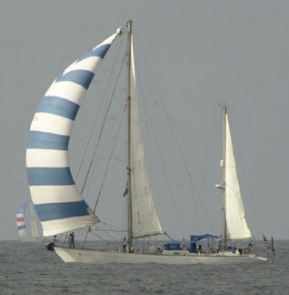
Photo Latitude/Richard

Owner Tony Clarke of Sonoma – who did more
than 500 group charters with her on San Francisco Bay, and who
sailed her to the Line Islands, Tahiti, Bermuda, the East Coast,
Bermuda, and the Caribbean over a period of 17 years – just informed
us that she sank on May 3 while on her way from Grenada to Trinidad.
“I suspect hull failure in the way of the mast step.”

Clarke and one crewman heard the bilge
alarm go off about 12:30 a.m. “It was blowing about 20 knots
with eight foot seas, nothing bad. There was no problem with
the sea chest, the sink drain, and the depthsounder thru-hull,
and initially there was no water forward or aft. But there was
so much water near the mast that the floorboards wouldn’t come
up. By 2:30 p.m., the bilge had flooded so much the engine quit.
We put out a distress call and cut the lifelines in order to
get the 450-lb liferaft over the side. We were picked up a short
time later by a boat from a British ship. Second Life
is now at the bottom in 500 feet of water. She can’t be recovered,
but hopefully it’s shallow enough so cameras can be lowered to
find out what happened.”


Looking Good Last Weekend

July 23 – San Francisco Bay

There was beautiful sailing on the Bay
last weekend, with lots of boats out to enjoy the excellent conditions.
Here are a few shots of some of them.


A couple of Bay View Boat Club’s Plastic Classic Regatta entries
split tacks heading upwind. In the distance to the right of them
you can see a Wylie Cat 30 reaching up the Bay while racing in
Island Yacht Club’s Silver Eagle Long Distance Race.


A big audience – of birds – watches from The Brothers as a Silver
Eagle entry heads into San Pablo Bay.


A couple of folks enjoy a vigorous beat on port tack, headed
in the direction of Raccoon Strait. It was blowing about 20 knots,
so they were probably getting ready to ease the traveler down.
Photos Latitude/Richard


A locally built Nor’West 33 reaching down the Bay south of PacBell
Park.


A grumpy looking spinnaker on what looks like a Cal 28 during
the Plastic Classic Regatta.


An Ariel 26 rounds the weather mark for the Plastic Classic.
Yes, that’s the San Francisco City Hall in the background. A
lot of you will probably enjoy knowing that we had a girlfriend
in high school whose grandfather built the metal dome for City
Hall.


Life Is Pretty Good in the Med

July 23 – Tuscan Islands, Italy

“We’re headed out from the Italian
Riviera to the Tuscan Islands tomorrow,” report Ken Burnap
and Nancy Gaffney of the Santa Cruz-based Amel Super Maramu 53
Notre Vie.


Isola d’Elba in the Tuscan Islands

“It’s a rough life, but someone has
to do it. We did not expect to be here in the high season, but
things are not as crowded as the guide book said they would be.
We have been able to get in all the fancy marinas except on weekends.
Anchorages are crowded during the day, but 75% of the boats go
back to the berths at the end of the day. My suggestion is to
get to the marinas early in the day, but the anchorages after
5 p.m.


Nancy Gaffney gives the Med two thumbs up.
Photo Courtesy Notre Vie


YOTREPS

July 23 – The Pacific Ocean and Cyberspace

Who is out making passages in the Pacific
and what kind of weather are they having? The YOTREPS daily yacht
tracking page has moved to www.bitwrangler.com/psn.


Weather Updates

July 23 Pacific
Ocean

San Francisco Bay Weather

Check out this guide to San Francisco Bay
Navigational Aids: http://sfports.wr.usgs.gov/sfports.html.

To see what the winds are like on the Bay
and just outside the Gate right now, check out http://sfports.wr.usgs.gov/wind.

The National Weather Service site for San
Francisco Bay is at www.wrh.noaa.gov/Monterey.

California Coast Weather

Looking for current as well as recent wind
and sea readings from 17 buoys and stations between Pt. Arena
and the Mexican border? Here’s the place – which has further
links to weather buoys and stations all over the U.S.: www.ndbc.noaa.gov/Maps/Southwest.shtml.

Pacific Winds and Pressure

The University of Hawaii Dept. of Meteorology
page posts a daily map of the NE Pacific Ocean barometric
pressure and winds.

Pacific Sea State

Check out the Pacific Ocean sea states
at: http://www.mpc.ncep.noaa.gov/RSSA/PacRegSSA.html.


For views of sea states anywhere in the world,
see http://www.oceanweather.com/data.


Top
/ Index of Stories
/
Previous 'Lectronic Edition

Subscriptions
/ Classifieds
/ Home

©2003 Latitude
38 Publishing Co., Inc.

The De-Naming Ceremony
I once met a man in Florida who told me he’d owned 24 different yachts and renamed every single one of them.