
|
|
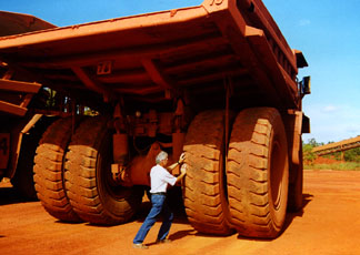
Over the Top in OzOctober 16 - Gove, Australia One of the important cruising events in Australia is the Over
the Top Rally from Gove to Darwin in July. Gove is at the northeastern
top of Australia, and as Andy Rothman of the San Francisco-based
J/44 'First Light' reports, "it's out in the middle of nowhere".
In fact, about the only thing there is a bauxite mine, which
is why you see Rothman pushing an ore-loading truck just outside
of Gove. |
  Photos Courtesy 'First Light' |
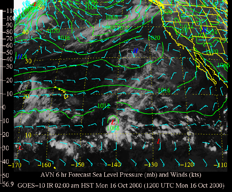
October 16 - Pacific and Atlantic Oceans
Once again, it's all quiet in both the Eastern Pacific/Mexican hurricane region and the Atlantic/Caribbean hurricane region. It's too early to say for sure, but there is a chance there won't be any more hurricanes in the Eastern Pacific or Atlantic/Caribbean.
To see what the winds are like on the Bay and just outside the Gate right now, check out http://sfports.wr.usgs.gov/wind/.
Looking for current as well as recent wind and sea readings from 17 buoys and stations between Pt. Arena and the Mexican border? Here's the place - which has further links to weather buoys and stations all over the U.S.: www.ndbc.noaa.gov/stuff/southwest/swstmap.shtml.
You can view the University of Hawaii Department of Meteorology satellite picture by clicking here.
Seas are normal in the Pacific, but you might check at: http://www.mpc.ncep.noaa.gov/RSSA/PacRegSSA.html.
For another view, see http://www.oceanweather.com/data/global.html.
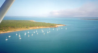
October 16 - Sea of Cortez
Everybody who goes to Mexico brings one of those English-Spanish
dictionaries, and usually a phrase book. These are good, of course,
but they're also slow and a pain. For example, suppose you're
a singlehander and want to meet a woman in Mexico. It would take
about 10 minutes to figure out how to say, "Good evening,
my name is Joe. I'm mesmerized by your eyes and wonder if you've
ever thought about sailing around the world with a gringo?"
We, however, came up with the proper translation, "Buenas
tardes, mi nombre es Joe que he sido mesmerized por sus ojos y
maravilla si usted ha pensado siempre de la navegación
alrededor del mundo?" in less than 10 seconds. As well as
the woman's response: "No, no tengo. Pero estoy buscando
a un hombre americano hermoso tal como se para ayudar me y a mi
familia extendida a trasladarse a los Estados Unidos." That
translates to: "No, I haven't. But I am looking for a handsome
American man such as yourself to help me and my extended family
move to the United States."
Anyway, you can find quick translations under 'Translate' at the
Alta Vista Web site on the Internet. No, you can't drag it around
town with you, but if you have to translate stuff, it's really
quite quick and cool. Give it a try, but remember mistakes are
common, as things get lost in the translation.
Gerry Cunningham, who has done all the great guidebooks to
the Sea of Cortez, warns about another kind of error in Mexico:
"I picked up a copy of the free 'Latitude 38's First Timer's Cruising Guide to
Mexico' as I left the Crew List Party at the Encinal YC, and
I want to commend you on an excellent piece of work. It should
be required reading for any cruiser going to Mexico, no matter
if they are going on the Ha-Ha or not. But I'd like make one clarification.
When it comes to your comments on "Charts and Cruising Guides",
you write the following: "When Charlie and the other authors
say their charts are 'Not to be used for navigation', they mean
it. I don't know if you've noticed or not, but there are no such
caveats on the various cruising guides I produce for the Sea of
Cortez. You see, I assume that the reason cruisers buy charts
is to aid their safe navigation of those waters. As such, I do
not use the old 1873-5 government charts for my grids and shorelines.
True, these Defense Mapping Agency charts served me well for over
40 years in the Sea of Cortez when we sailed with nothing but
a compass and my eyes for navigation. However, now that we have
GPS telling us within feet of where we actually are, such inaccurate
charts can be dangerous.
"And these charts can be more than a little inaccurate and
dangerous. For example, #21008 Golfo De California, Northern Part,
is as much as two miles off station at Santa Rosalia and to the
north. And it's a mile off around Conception Bay, up at Puerto
Refugio, and north of San Carlos on the mainland. These errors
are naturally perpetuated in all of the copies of these charts,
whether paper or electronic. This is why I use the only modern
survey made of the Sea of Cortez. Back in the '60s, the United
States and Mexico did a well controlled aerial survey of all of
Mexico, and all the current topographical charts for Mexico are
based on that data. These maps have proved out nicely with GPS.
"A few weeks ago, we had occasion to make our way into the
little harbor at Santa Rosalia. There was a rambunctious squall,
and naturally it was the middle of the night. We'd plotted a waypoint
off the harbor entrance from my Santa Rosalia Mini-Guide, and
as nearly as we could tell in the dark, it put us right where
we expected to be. Had we taken this waypoint off #21008, we would
have been a mile or so inland.
"Although using those original charts may be 'romantic',
you have to remember they are not accurate. The 'Not For Navigation'
caveat should be on those oldies as well as many of the current
'sketch charts'."
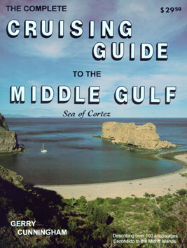 One of Gerry's Sea of Cortez Cruising Guides |
October 16 - The Pacific Ocean and Cyberspace
Who is out making passages in the Pacific and what kind of weather are they having? Check out YOTREPS - 'yacht reports' - at http://www.bitwrangler.com/yotreps/
Top / Index of Stories
/ Subscriptions
/ Classifieds
/ Home©2000 Latitude 38 Publishing
Co., Inc.