Skip to content

August 26, 2003


Photos of the Day: Hurricane Ignacio

August 26 – La Paz, BCS

Hurricane Ignacio passed through La Paz
yesterday, and our Photos of the Day were taken by our old friend
Boone Camp. At this point NOAA reports that the storm is weakening
quickly over the mountainous terrain of the Baja peninsula. Even
if it reemerges off the west coast of Baja, the waters there
are apparently too cool to allow regeneration to hurricane status.

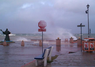
But as the hurricane approached La Paz
on Sunday night and the future was uncertain, officials evacuated
over 3,000 people, who spent the night in shelters. Winds topped
90 mph, but the extensive rain and flooding that was expected
mercifully never occurred. The Red Cross reports no deaths or
major injuries. One car accident in La Paz was caused by excess
water in the streets.

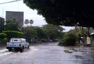
The wind came out of the north onto the
bay, so a number of boats ripped loose and ended up on the shore
or the rocks. At last report, only one boat was sunk in La Paz
Harbor. Marina de la Paz says that there was a little damage
to their outside docks, but no damage to their boats or dry storage.


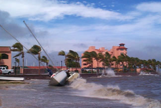
Photos Boone Camp

Boone reports this morning that the city
is still suffering sporadic interruptions in electricity and
water, and lots of trees are down. All evacuees have returned
home, save for about 400 folks who live in shacks or dangerous,
flimsy dwellings, and officials are taking care to see that they
are fed and well cared for.

Hurricane Ignacio has been downgraded to
a Tropical Storm and it seems as though the worst is over, and
it wasn’t so bad.


YOTREPS

August 26 – The Pacific Ocean and Cyberspace

Who is out making passages in the Pacific
and what kind of weather are they having? The YOTREPS daily yacht
tracking page has moved to www.bitwrangler.com/psn.


Weather Updates

August 26 Pacific
Ocean

San Francisco Bay Weather

Check out this guide to San Francisco Bay
Navigational Aids: http://sfports.wr.usgs.gov/sfports.html.

To see what the winds are like on the Bay
and just outside the Gate right now, check out http://sfports.wr.usgs.gov/wind.

The National Weather Service site for San
Francisco Bay is at www.wrh.noaa.gov/Monterey.

California Coast Weather

Looking for current as well as recent wind
and sea readings from 17 buoys and stations between Pt. Arena
and the Mexican border? Here’s the place – which has further
links to weather buoys and stations all over the U.S.: www.ndbc.noaa.gov/Maps/Southwest.shtml.

Pacific Winds and Pressure

The University of Hawaii Dept. of Meteorology
page posts a daily map of the NE Pacific Ocean barometric
pressure and winds.

Pacific Sea State

The site for the Pacific Ocean sea states
has moved to http://www.mpc.ncep.noaa.gov/shtml/PacRegSSA.shtml.


For views of sea states anywhere in the world,
see http://www.oceanweather.com/data.


Top
/ Index of Stories
/
Previous 'Lectronic Edition

Subscriptions
/ Classifieds
/ Home

©2003 Latitude
38 Publishing Co., Inc.

The De-Naming Ceremony
I once met a man in Florida who told me he’d owned 24 different yachts and renamed every single one of them.