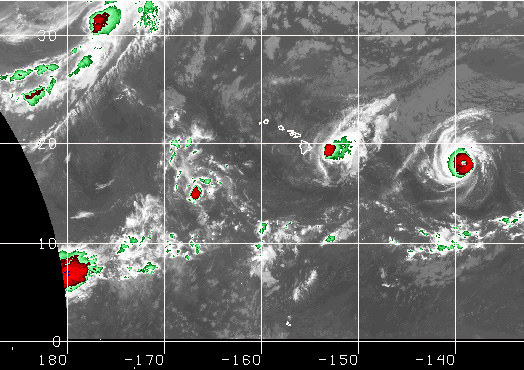
Dual Hurricanes Threaten Hawaii
While many Americans are stocking up on hotdogs, hamburgers and beer for much-anticipated Labor Day Weekend barbecues, many Hawaiians are stocking up on batteries, bottled water and non-perishable foods as dual hurricanes approach.

As of this morning, Category 1 Hurricane Madeline was centered about 140 miles ESE of Hilo, Hawaii (the Big Island), and packing max sustained winds of 90 mph (78 knots) with higher gusts. Moving ENE at about 14 knots, it is expected to pass near the Big Island’s south coast tonight, bringing surf as high as 25 feet and plenty of rain.
A few days later — most likely late Saturday — the effects of Hurricane Lester will challenge island infrastructure again. Currently located about 1,000 miles east of Hilo and rated as a Category 4, Lester is now packing sustained winds of 130 mph (113 knots). Moving west this morning at 12 knots, the system’s current track would take it just north of the Hawaiian Island chain. But that could change, of course, for better or worse. Lester is the 12th named storm of the Eastern Pacific Hurricane Season, and the sixth to become a hurricane.
