Skip to content

June 7, 2002


Photos of the Day

June 7 –
Southern California

Today’s Gloomy Photos of the Day are from
chilly Southern California. June stands for gloom in Southern
California, as the marine layer sets in thick. For example, at
11 a.m. this morning, it was only 62 degrees at Long Beach, while
it was 63 in San Francisco. Stockton, where the Ditch Run fleet
is heading, was already 81.

So far this June, it’s been sunnier and
warmer in Northern California than Southern California. By the
end of the month, that’s going to change for about 11 more months.


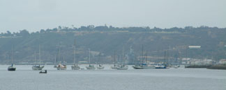
Boats anchored in the gloom off Shelter Island, San Diego


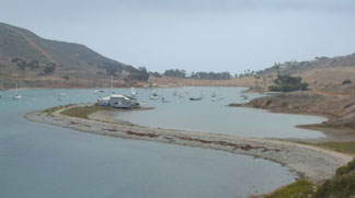
Gloomy Cat Harbor, Santa Catalina Island
Photos Latitude/Richard
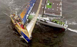

Down to the Last Leg of the Volvo

June 7 – Gothenburg, Sweden

After some 32,000 miles of the most competitive
ocean racing in the world, the Volvo Ocean Race is coming down
to tomorrow’s 250-mile final leg from Gothenburg, Sweden, to
Kiel, Germany. There are only two boats that can mathematically
still win: illbruck, the German entry skippered by Marin’s
John Kostecki, which has a commanding lead; and Assa Abloy,
co-skippered by Mark Rudiger, another Marin resident. If Assa
wins this leg and illbruck finishes sixth, the boats will
tie with 57 points and Assa will win the tie-breaker.
That, however, is not likely to happen.

Says Mark Rudiger, Assa
Abloy’s
navigator, “I think illbruck wants to
cover us the whole leg, that is clear. They will give us a tight
cover if they are ahead, and a loose cover if they manage to
pull away a bit further. And if they are behind us, they will
follow our course, I presume. Some people think that between
the islands, in the narrow passages, there are no passing lanes,
but I think that is where a lot of things can happen as things
change quickly in the light conditions in there.”


Photo Rick Tomlinson
Courtesy www.volvooceanrace.com


The Delta Ditch Run

June 7 – San Joaquin River

For Northern California racers, there’s
something much more important – and fun – than the last leg of
the Volvo. The Delta Ditch Run. May everyone’s jibes be clean
and their keels stay out of the mud.


Crossing the Sea of Cortez

June 7 – La Paz, BCS

Peter Boyce of the Sabre 42 Edelweiss
III
reports having just had a wonderful sail across the Sea
of Cortez from Mazatlan to La Paz. “We did the 252 miles
in 45 hours, with only 12 of those being motorsailing. It was
wonderful. We were on port tack the entire way, beam reaching
or close reaching in five to 15 knots.”

Note that Edelweiss was on port
tack. In the winter, the wind in the Sea is out of the north
almost all of the time. In the summer, the wind is normally out
of the south.


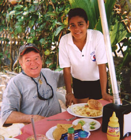
That’s Peter on the left.
Photo Marlaina Pipal


Surfing the Entrance at El Salvador

June 7 – Bahia Del Sol, El Salvador

“We arrived at Bahia Del Sol, El Salvador,
yesterday afternoon after setting out on the beach for seven
hours with this huge – and I mean huge! – swell running,”
reports Guy Bunting of the M&M 46 cat Elan.


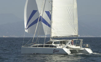
Photo Latitude/Richard

“The breakers on the bar were so big
that we could clearly see them on radar from four miles out.
So, the guide boat comes out to get us a few hours before slack
when the waves are looking a little better. Now, I’m assuming
there’s a path through the bar. A kind of serpentine affair –
slip between this set of breakers, run parallel through a calm
zone, then slip inside sort of thing. That’s for sissies! What
WE do is find slot with sort of smaller waves and floor it! I
see the damn guide panga disappear – totally disappear – behind
a huge wave running straight into the lagoon. Christ! So I floor
it and never look back. Suddenly Elan’s stern lifts, and
when I look back, I say, “Oh shit!” Elan takes
off exactly like a surfer on a wave, and we catch the wave. With
the engines throttled back, we hit 17 knots as we ride it out.
The guy driving the panga in front looked back at us with eyes
as big as pancakes as we bore down on him. I’m giving him a look
that says, ‘We’ve got no brakes, you know.’ Once we got in, the
entrada was closed for existing boats for more than two
weeks. It was sort of a ‘you can check in any time you want,
but you can never leave’ deal. But it’s open now.”


No Need to Baja Bash – If You Have Time

June 7 – Coast of Baja California

The worst time to make the Baja Bash from
Cabo to San Diego is usually the spring – when everybody wants
to do it. If you’ve got the time – and the guts – hurricane season
isn’t a bad time to make the run. Alex Malaccorto and Rocinante
report they departed Cabo after watching Hurricane Alma do her
thing, and so far “we have seen nothing over 15 knots, even
in the late afternoons, and are having a most enjoyable trip.”

One thing that has helped are the new weather
tools available from both Winlink and SailMail. “These are
digital weather charts showing isobars and wind charts for a
specified period,” Alex continues. “We are using 72
hours. These files are displayed on top of your chart and can
be played like a movie loop. We use a one hour increment. They
have been excellent at showing the weather along the California
coast. Since we are not on a schedule, we stay put in anchorages
until the isobars show light wind ahead.”


YOTREPS

June 7 – The Pacific Ocean and Cyberspace

Who is out making passages in the Pacific
and what kind of weather are they having? Check out YOTREPS –
‘yacht reports’ – at http://www.bitwrangler.com/yotreps/


Weather Updates

June 7 – Pacific Ocean

San Francisco Bay Weather

To see what the winds are like on the Bay
and just outside the Gate right now, check out http://sfports.wr.usgs.gov/wind/.
The National Weather Service site for San Francisco Bay is at
www.wrh.noaa.gov/Monterey/.

California Coast Weather

Looking for current as well as recent wind
and sea readings from 17 buoys and stations between Pt. Arena
and the Mexican border? Here’s the place – which has further
links to weather buoys and stations all over the U.S.: www.ndbc.noaa.gov/stuff/southwest/swstmap.shtml.

Pacific Winds and Pressure

The University of Hawaii Dept. of Meteorology
page posts a daily
map
of the NE Pacific Ocean barometric pressure and winds.

Pacific Sea State

Check out the Pacific Ocean sea states
at: http://www.mpc.ncep.noaa.gov/RSSA/PacRegSSA.html.


For another view, see http://www.oceanweather.com/data/global.html.


Top
/ Index of Stories /
Subscriptions
/ Classifieds
/ Home

©2002 Latitude
38 Publishing Co., Inc.

The De-Naming Ceremony
I once met a man in Florida who told me he’d owned 24 different yachts and renamed every single one of them.